


Hurricane Humberto Expected to Rapidly Intensify as Atlantic Storms Threaten with Rare Fujiwhara Effect
Hurricane Humberto is rapidly gaining attention after forming in the central Atlantic, nearly 550 miles east of the northern Leeward Islands. The storm, which started as a tropical system with winds around 40–45 mph, is now forecast to intensify significantly over warm Atlantic waters. Moving west-northwest at roughly 10–15 mph, Humberto is expected to become a major hurricane by early next week, with potential sustained winds surpassing 115 mph.
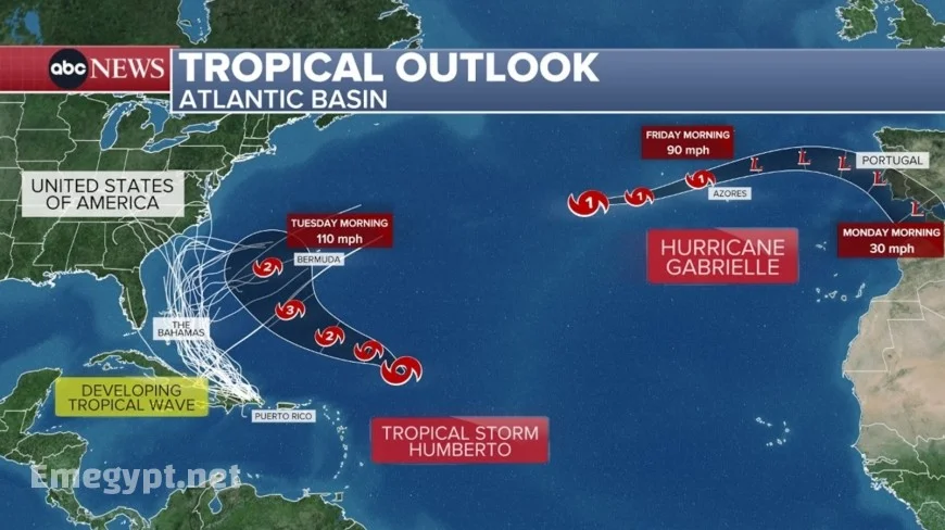
Hurricane Humberto is rapidly gaining attention after forming in the central Atlantic, nearly 550 miles east of the northern Leeward Islands. The storm, which started as a tropical system with winds around 40–45 mph, is now forecast to intensify significantly over warm Atlantic waters. Moving west-northwest at roughly 10–15 mph, Humberto is expected to become a major hurricane by early next week, with potential sustained winds surpassing 115 mph.
Meteorologists highlight that while no immediate landfall warnings have been issued, the storm’s sheer size and intensity could generate dangerous surf, rip currents, and hazardous marine conditions along Bermuda and the eastern U.S. coastline.
Forecast Models Show Growing Risk of Rapid Intensification
Current weather models align on the likelihood of Hurricane Humberto evolving into a major hurricane. Factors fueling its strength include:
-
Warm sea surface temperatures above average
-
Favorable atmospheric conditions with low wind shear
-
Strong outflow patterns supporting storm development
A table summarizing Humberto’s projected growth stages:
| Forecast Stage | Estimated Timeline | Wind Speed (mph) |
|---|---|---|
| Tropical Storm | Current | 40–45 |
| Category 1 Hurricane | Within 48 hours | 75–95 |
| Category 2 Hurricane | 3–4 days | 100–110 |
| Category 3+ Major Hurricane | Early next week | 115+ |
Invest 94L and the Growing Threat of Imelda Tropical Storm
As Hurricane Humberto intensifies, attention also shifts to Invest 94L, a tropical disturbance near Hispaniola that is likely to develop into Imelda tropical storm. Early projections suggest two possible tracks:
-
Movement toward the Bahamas and potentially the U.S. East Coast, bringing heavy rains and strong winds.
-
A stall or shift offshore, where the system could interact with Hurricane Humberto in the Atlantic.
This dual storm setup raises concerns about stronger coastal impacts, including flooding and disruptions in shipping lanes.
The Fujiwhara Effect: How Two Storms Could Collide
A rare meteorological event, the Fujiwhara effect, is being closely monitored by experts. If Hurricane Humberto and Imelda tropical storm approach each other closely enough, they could begin rotating around a common center. This unusual phenomenon can cause sudden and unpredictable changes, such as:
-
Altered storm tracks, pulling one or both systems closer to land
-
Potential merging into a larger, more powerful system
-
Extended duration of storm threats in the Atlantic
Such interactions are difficult to forecast with precision, but they highlight why residents along the East Coast and Bermuda must stay updated on advisories.
Atlantic Hurricane Season Shows No Signs of Slowing Down
The 2025 Atlantic hurricane season continues to demonstrate above-average activity. With Hurricane Humberto and the potential development of Imelda tropical storm, meteorologists warn of heightened risks for coastal communities.
Key factors shaping the season:
-
Warmer-than-usual Atlantic waters fueling storm strength
-
Increased frequency of tropical disturbances
-
Long-track storms forming earlier and lasting longer
The East Coast tropical risk remains elevated through the coming weeks, particularly if the Fujiwhara effect materializes.
Bermuda and East Coast Tropical Risk on High Alert
Although no direct landfall from Hurricane Humberto is projected at this time, Bermuda remains under heightened watch due to its proximity to the storm’s forecast path. Meanwhile, the U.S. East Coast faces indirect hazards:
-
Large ocean swells reaching beaches from Florida to the Carolinas
-
Strong rip currents posing dangers to swimmers and boaters
-
Possibility of heavy rains and gusty winds if Imelda tropical storm shifts westward
Authorities urge residents and travelers in affected regions to remain cautious as forecasts evolve.
Tracking Humberto, Imelda, and the Atlantic Outlook
The coming days will be critical in determining how Hurricane Humberto develops and whether Imelda tropical storm becomes a direct threat to the U.S. East Coast. The Fujiwhara effect remains a wild card, with the potential to dramatically shift storm behavior.
As the Atlantic hurricane season continues, weather services emphasize that preparation is essential, even in areas not directly in a storm’s path. With multiple systems active, vigilance is the key to minimizing risk and ensuring safety.


