


Imelda and Humberto bring double danger with perilous surf and coastal flooding threatening US and consecutive hurricanes targeting Bermuda
**Imelda and Humberto Intensify: A Double Threat to the U.S. and Bermuda**
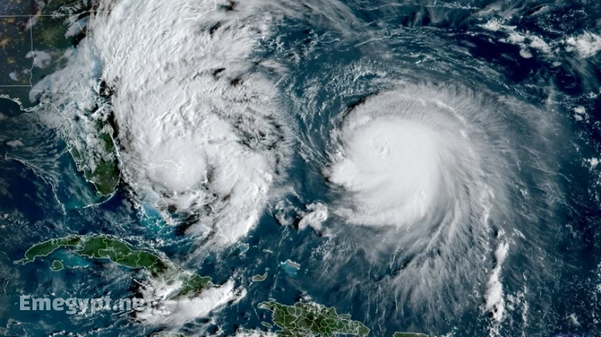
Tropical Storm Imelda is gaining strength and is on track to become a hurricane by Tuesday, as it moves off the Southeast coast. From Florida to the Carolinas, the system is expected to generate hazardous surf conditions, including rip currents, coastal flooding, and beach erosion.
Dual Storm Threats: Imelda and Humberto Complicate Forecasts
Concurrently, Hurricane Humberto, which briefly advanced to a Category 5 storm on Saturday with winds reaching 160 mph, has diminished to a formidable Category 3 hurricane. Situated several hundred miles east of Imelda, Humberto’s extensive reach will exacerbate risks for U.S. beaches by projecting perilous rip currents and massive waves farther up the East Coast than Imelda alone could achieve.
Imelda’s Changing Path and Impact on the U.S. Coast
The center of Imelda is anticipated to remain offshore, marking a pivotal change in the forecast since last weekend. Despite this, the storm’s extensive system will still bring rainy weather to certain regions. Coastal Carolinas might experience localized flash flooding through Tuesday, although rainfall predictions have reduced significantly to an inch or less in many areas. Coastal flooding remains a possibility from Florida’s Space Coast to North Carolina’s Outer Banks, where onshore winds may elevate water levels 1 to 2 feet above normal high tide.
Bermuda Prepares for Humberto and Imelda
While the Bahamas faced Imelda’s powerful winds and heavy rain over the past weekend, as of Monday evening, Imelda hovered approximately 200 miles east of Cape Canaveral, Florida, with sustained winds of 65 mph according to the National Hurricane Center. The storm is forecasted to escalate into a hurricane by early Tuesday as it moves parallel to Florida’s Atlantic Coast before sharply turning into open waters. This shift is influenced by Hurricane Humberto, which will divert Imelda away due to its strength and positioning.
Emergency Responses in the Southeast
This interaction between Imelda and Humberto is why the threats of flooding and high winds have diminished for the United States compared to earlier predictions. Southeastern officials had initially responded to the storm’s threat with proactive measures. On Friday, South Carolina Governor Henry McMaster declared a state of emergency, initiating statewide response protocols, which were rescinded by Monday. Charleston, South Carolina, declared a local state of emergency on Saturday, starting sandbag distribution and drain clearances. Additionally, North Carolina Governor Josh Stein declared a state of emergency to prepare resources.
Bermuda Braces for a One-Two Punch
Bermuda is prepared for a rare double confrontation, facing Humberto’s powerful passage to the west of the island Monday into Tuesday, which will bring rain, high winds, and dangerous surf. Following closely is Imelda, which could approach even nearer, potentially making direct landfall between Wednesday and Thursday. The island could see up to four inches of rain, prompting the Bermuda Weather Service to issue a hurricane watch on Monday afternoon.
A Unique Hurricane Season for the U.S.
This hurricane season remains without a direct hurricane landfall in the U.S. Despite Tropical Storm Chantal hitting South Carolina in July, no storms have made landfall at hurricane strength in 2025. If this trend continues, it would be the first time in ten years without such an event. Notably, every hurricane this year — Erin, Gabrielle, and Humberto — has reached major hurricane categories this early in the season, a phenomenon not observed since 1935. The occurrence of rapid storm intensification is becoming significantly more common with the ongoing warming of the planet due to fossil fuel emissions.


