


Tropical Storm Imelda Forms with Major Shift in Forecasted Path – Essential Details Inside
Tropical Storm Imelda Heads Towards Intensification Over the Atlantic
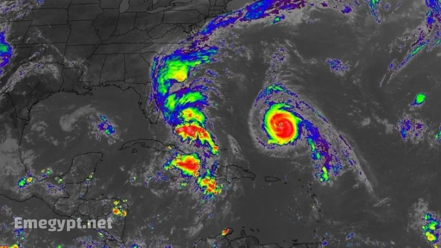
Imelda’s Development and Impact on the Bahamas
Tropical Storm Imelda has emerged over the Bahamas and is on track to intensify into a hurricane. As of Sunday evening, the storm clocked maximum sustained winds of 40 mph and positioned itself 335 miles southeast of Cape Canaveral, Florida. The National Hurricane Center has issued tropical storm warnings for the central and northwestern Bahamas, where heavy rainfall ranging from 4 to 12 inches is expected, presenting a risk of flash flooding.
Imelda’s Projected Path and the Impact on the Southeast Coast
Recent forecasts show Tropical Storm Imelda veering away from a direct landfall on the Southeast US coast. The storm is anticipated to travel north and parallel to Florida’s Atlantic coast before abruptly turning east, likely intensifying into a hurricane by late Monday or Tuesday. Consequently, tropical storm watches have been lifted for segments of Florida’s east coast.
The Interplay Between Imelda and Hurricane Humberto
Imelda joins Hurricane Humberto in a complex atmospheric scenario over the Atlantic. Hurricane Humberto, having ramped up to a Category 5 storm, plays a pivotal role in determining Imelda’s trajectory. By Tuesday, Humberto will influence Imelda to shift further away from the Southeast coast, despite efforts from weather patterns that could draw it inland. While the risk of significant wind impacts is decreasing, residents along the southeastern US coast should stay informed of ongoing forecast updates.
Expected Weather Conditions Along the Southeast Coast
The Southeast coast is likely to experience early signs of Imelda’s influence by Monday. Regions along eastern Florida, Georgia, and the Carolinas should brace for potential flooding rains and high surf triggered by onshore winds. Rainfall amounts of 2 to 6 inches are anticipated in the coastal Carolinas through Wednesday morning, coupled with strong, gusty winds and possible beach erosion.
Preparations and State of Emergency Declarations
Despite encouraging forecasts, officials in the Southeast are preparing for Imelda’s impact. South Carolina Governor Henry McMaster has declared a state of emergency, mobilizing resources to manage possible wind, rain, and storm surge threats. Charleston has also declared a local state of emergency, distributing sandbags and ensuring storm drains are clear.
Hurricane Humberto’s Movement Towards Bermuda
Over the open Atlantic, Hurricane Humberto weakened slightly to a robust Category 4 storm. It’s expected to maintain its intensity as it steers west of Bermuda, though the island might experience rain bands and gusty winds through midweek. As a precaution, the Bermuda Weather Service has issued a tropical storm watch.
While Imelda seems unlikely to severely impact the United States, it is advised that residents from the Bahamas to Bermuda, as well as the US Southeast coast, remain vigilant and monitor forecast updates.


