


Tropical Storm Jerry on the Horizon Set to Approach Leeward Islands This Week
Catch the Latest on ‘Future Jerry’ and Potential Atlantic Storm Development
The Atlantic is bracing for potential storm developments as the National Hurricane Center (NHC) keeps an eye on a tropical disturbance that could soon become Tropical Storm Jerry. This system is currently gaining strength in the Atlantic Basin and may impact the Leeward Islands before curling north into open waters. Meanwhile, the far southwest Gulf is also under observation for slight development possibilities.
Current Status of the Atlantic System
A tropical wave, known as “Invest 95L,” is making its presence felt between Africa and the Lesser Antilles. The NHC uses the term “invest” to signify areas that require focused monitoring for potential development. This tropical wave is showing signs of becoming more organized.
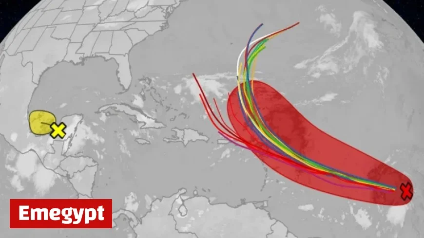
Should conditions necessitate, a Hurricane Hunter mission is planned for Wednesday morning to assess the situation further. The latest NHC outlook provides a color-coded map, detailing areas with potential tropical cyclone development over the next week, with current disturbances marked by an “X.”
Projected Path and Potential Impact of 95L
The disturbance is moving west-northwest and is anticipated to pass near the Leeward Islands by Thursday night or Friday. Forecast models suggest the possibility of this system evolving into Tropical Storm Jerry, marking it as the 10th storm of the 2025 hurricane season.
While its trajectory beyond this point is uncertain, prevailing models indicate a northern shift into the central Atlantic, a common pattern this season. This trajectory would spare the mainland U.S. from potential threats. The timing of the northward move is critical for determining the impact on the Leeward Islands, Puerto Rico, and the Virgin Islands, differentiating between substantial showers and moderate winds or milder weather conditions.
Southwest Gulf: Monitoring Another System
In the southwest Gulf, another area of interest persists over the Yucatán Peninsula in Mexico. The NHC highlights this region with an “X” and tracking features in its map. While there is currently less than a 50% chance for development in the Bay of Campeche, the system could advance towards eastern Mexico by Thursday.
Despite the low probability of becoming a storm, this system poses a risk of heavy rainfall, potentially causing flooding in Belize, northern Guatemala, and southern Mexico over the next few days.
- Heavy rainfall forecast for Belize and neighboring regions
- Tropical disturbances under scrutiny in the Atlantic and Gulf areas
- Potential development into Tropical Storm Jerry
Stay updated with Emegypt regarding these systems and other related developments during the 2025 Atlantic hurricane season. For expanded coverage on unusual weather patterns, connect with meteorologist Jonathan Erdman through social platforms like Bluesky, X (formerly Twitter), and Facebook.


