


East Coast Braces for Intense Nor’easter with Heavy Rain Wind and Coastal Flooding This Weekend
Northeast Storm Brewing: Major Nor’easter Expected to Impact East Coast from Florida to the Mid-Atlantic
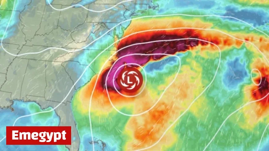
A developing nor’easter off the Southeast coast is set to bring significant weather threats to the East Coast through the weekend. Originating from a strong cold front moving across the United States, this storm promises to deliver crisp, autumnal weather. However, as it slows and stalls over the Southeast, it will spawn a full-fledged coastal storm.
Coastal Storm to Bring Rain and Wind to Florida and the Carolinas
The nor’easter, projected to form on Saturday, could unleash rough seas, substantial coastal rains, and powerful winds from Florida through the Carolinas and into the mid-Atlantic. The Weather Prediction Center describes this event as potentially “rather significant.”
Nor’easters, which derive their name from the northeast winds hitting the coast, are most frequent from September through April, typically forming between Georgia and New Jersey. While they are known for heavy snow in winter, they can bring substantial rainfall at any time.
Environmental Impacts and Forecast Scenarios
The strongest nor’easters are increasingly intensified by climate change, as highlighted by a July study. The current storm’s impact remains uncertain, with two potential scenarios:
- Scenario One: The storm develops off the coast between Florida and South Carolina, strengthening on Sunday, and lingers near the Carolinas through Tuesday. This could result in up to half a foot of rain and gusty winds along the coast.
- Scenario Two: The storm forms in a similar area and travels north towards North Carolina, bringing rain and winds to the mid-Atlantic and New England coasts, but lessening impacts on the Southeast coast.
Regional Impacts and Weather Concerns
Eastern North Carolina could bear the brunt, with several inches of rain expected from Friday into early next week. The Outer Banks may receive near 6 inches of rain, leading to localized flash flooding.
Coastal winds will begin Friday, peaking from Saturday to Sunday. The Outer Banks could experience gusts up to 50 mph, with other parts of eastern North Carolina expecting 20 to 40 mph gusts.
Multi-day coastal flooding is a risk, particularly in the Outer Banks, as tide levels will approach their highest this month.
Aftermath and Future Weather Patterns
Once the storm subsides, the Southeast can expect a brief pause in adverse weather before the arrival of another unseasonably warm front late next week.
Stay informed with Emegypt for the latest updates on this developing storm and its impacts on the East Coast.


