


Rainy Wednesday Morning Commute and Afternoon Chill: Your Hour-by-Hour Forecast
Inland Heat to End as Cold Front Approaches New England
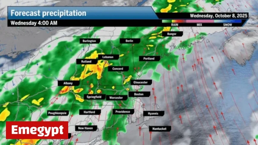
Cold Front Brings Rain and Cooler Temperatures to New England
For the fourth consecutive day, inland New England experienced temperatures soaring to the 80-degree mark, an unusual pattern for early October. However, this prolonged warmth is set to conclude as a fast-approaching cold front makes its presence felt. As it sweeps through the region, this front will deliver much-needed rainfall during the first part of Wednesday.
Early commuters on Wednesday may sidestep the heaviest rain but should expect showers and occasional downpours, along with thunder, particularly in the Boston area. Rainfall totals are estimated to reach between half an inch and 1½ inches, with heavier localized downpours possibly exceeding these amounts. The morning commute across New England is likely to be wet, with steady to scattered showers prevailing.
Forecasted Weather Changes Across New England
The morning of Wednesday will start off with warmer-than-usual temperatures in the 60s, with humidity lingering until drier air filters in during the afternoon. Across New England, temperatures are expected to climb into the upper 60s, accompanied by breezy conditions as the wind shifts from southwest to north, bringing in colder air.
Clearing skies are anticipated before sunset on Wednesday as New England begins to dry out, leading to night-time temperatures dropping into the 40s. Most areas will see up to an inch of rain by mid-Wednesday, with clouds decreasing as the day progresses.
Sunny and Cooler Conditions Ahead
Thursday ushers in ample sunshine with quintessentially autumnal air. Daytime temperatures will struggle to reach the mid-50s, and those with outdoor plants or gardens may need to take precautions Thursday night into Friday, especially in inland areas prone to frost. A frost or even a freeze is likely for Friday morning in typically colder spots.
By Friday afternoon, temperatures will recover into the 60s, and the risk of frost diminishes for at least a week. Looking ahead to the weekend, the forecast appears seasonable with temperatures ranging in the 60s on Saturday and slightly cooler in the low 60s on Sunday. However, a few clouds might appear along with a chance of a shower.
NNY Weather Outlook for Wednesday and Beyond
- Greater Boston: Expect showers during the first half of Wednesday, with potential downpours and thunder. Temperatures will cool to the 60s.
- Central/Western Massachusetts: Thunder and showers Wednesday morning will clear by late afternoon, with highs in the 60s. Sunny conditions anticipated on Thursday with temperatures in the 50s.
- Southeastern Massachusetts: Morning showers, with a shift from a southwest breeze to north in the afternoon. Sunshine returns Thursday with highs in the 50s.
- Cape and Islands: Rain commencing Wednesday morning with clearing by nightfall. Temperatures will peak in the 60s on Wednesday and hover around 60 on Thursday.
- Rhode Island: Early showers on Wednesday will fade by early afternoon, transitioning to bright sunshine Thursday with highs in the 50s.
- New Hampshire: Rain ceases before noon on Wednesday, with highs in the mid-60s. Thursday brings sunshine and breeziness with highs in the 50s.
Sign up with Emegypt for our daily Weather Forecast to have it delivered straight to your inbox each weekday morning.


