


Tropical Storm Jerry Set to Strengthen into Hurricane See its Projected Path Across Central Atlantic
Tropical Storm Jerry Threatens Atlantic: Updates and Forecast
Tropical Storm Jerry Developing in the Central Atlantic
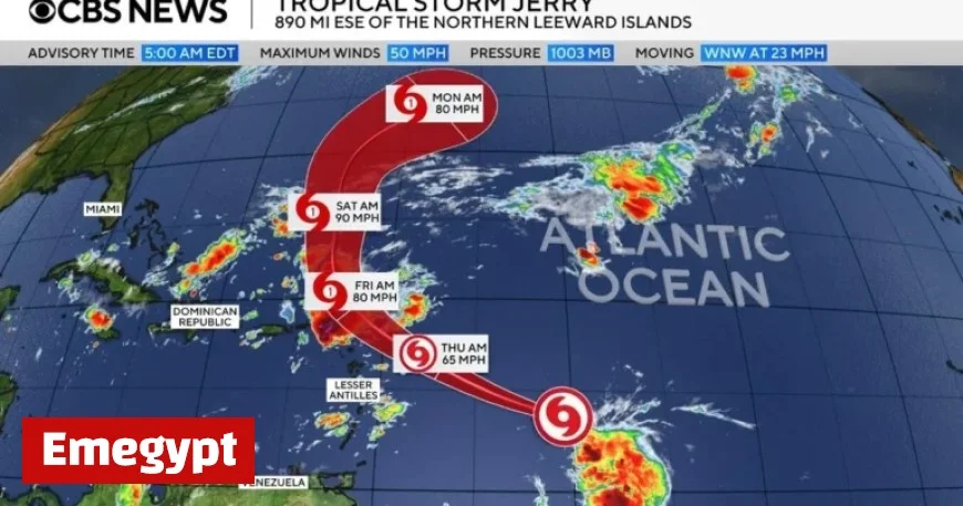
Tropical Storm Jerry continues to intensify over the central Atlantic Ocean, according to the Miami-based National Hurricane Center. Formed recently, Jerry marks the tenth named storm of the 2025 Atlantic hurricane season, currently situated about 505 miles east-southeast of the northern Leeward Islands. This region forms the eastern Caribbean chain, extending from the Virgin Islands to Guadeloupe.
Weather Forecast: Jerry’s Predicted Path and Strength
With maximum sustained winds of 65 mph, Jerry moves west-northwest at 18 mph across open waters. Forecasters suggest that the storm may gain strength, potentially becoming a hurricane later this week with sustained winds reaching at least 74 mph. A tropical storm watch remains in effect for several islands, including:
- Antigua
- Barbuda
- Anguilla
- St. Kitts and Nevis
- Montserrat
- St. Barthelemy
- St. Martin
- Saba and St. Eustatius
- Guadeloupe
Projected Weather Impacts on the Leeward Islands
The hurricane center predicts Jerry’s core will be near or north of the northern Leeward Islands by late Thursday and Thursday night. No threat to southern Florida is anticipated at this time. Expected weather impacts include two to four inches of rain across the Leeward Islands, raising concerns of flash flooding, particularly in areas with higher terrain.
Marine Hazards: Life-Threatening Conditions Expected
Swells from Jerry are expected to affect the Leeward and Windward Islands starting Thursday, subsequently reaching the Greater Antilles. These conditions may lead to dangerous surf and rip currents, posing significant risks to life and property.
Atlantic Hurricane Season Overview
Jerry’s development follows other recent Atlantic storms such as Hurricane Humberto and Hurricane Imelda, both of which posed initial threats to Bermuda. While Imelda briefly impacted Bermuda as a Category 2 hurricane, both storms brought destructive surf to the southeastern United States, especially impacting coastal areas in North Carolina’s Outer Banks.
This year’s hurricane season, extending from June 1 to November 30, has been relatively calm. Although Jerry is the tenth named storm, only Hurricane Chantal has made landfall in the U.S. Originally, the National Oceanic and Atmospheric Administration (NOAA) projected 13 to 19 named storms, with up to nine becoming hurricanes. However, adjustments in August revised these figures to 13 to 18 named storms, including five to nine hurricanes, indicating a slightly less active season.


