


Desert Southwest Braces for Torrential Rainfall as Former Hurricane Priscilla Intensifies
Severe Flood Threat Looms Over U.S. Southwest as Storms Converge
Unprecedented Rainfall to Hit Dry Regions
An impending flood risk emerges for the typically arid regions of the United States as the remnants of Hurricane Priscilla unite with another storm system, promising an extended period of substantial rainfall. As the week concludes, areas in the Southwest may experience rainfall exceeding their typical October averages. Another tropical system following in Priscilla’s wake could exacerbate flood risks early next week.
Priscilla’s Impact on The Southwest
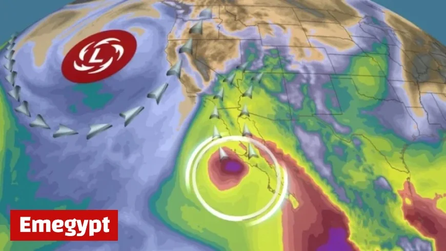
Once a hurricane, Priscilla is transforming into a tropical storm, saturating the Southwest U.S. with near-record levels of atmospheric moisture. This abundance of moisture acts like a water-soaked sponge, ready to release downpours when storm systems wring it out. Priscilla’s dissipation is expected west of the Baja California Peninsula, but its moisture-laden air will be absorbed by a weather system moving through a jet stream dip along the West Coast—a classic pattern responsible for sending hurricane remnants from the Eastern Pacific into the Southwest U.S., often resulting in flooding rainfall.
Forecast for Heavy Rain and Flash Flooding
Rain showers are projected to intensify from Thursday through Friday, spanning regions from Arizona and southeast California to the Four Corners. The peak of this torrential weather is likely to occur between late Friday and Saturday, with potential flash floods imminent, particularly in low-lying terrains. Areas such as washes, small streams, creeks, and slot canyons are especially susceptible; hence, avoiding these locations is advisable.
- Phoenix could surpass its average October rainfall of just over half an inch in a single day or two.
- Flagstaff requires an inch and a half of rain to meet its monthly average, a seemingly minimal amount that can still provoke significant issues due to rapid runoff on parched ground.
Recent Weather Patterns Exacerbating Drought
The memory of last month’s heavy downpour in Globe, Arizona, where two inches of rain fell in 30 minutes, leading to a destructive flood, remains fresh. Although Phoenix recently experienced one of its wettest Septembers, recording 2.26 inches, the area remains in severe to extreme drought.
Looking Ahead: Next Wave of Storms
Northern Arizona may bear the brunt of the rain, with potential accumulations of up to 3 or 4 inches. The Weather Prediction Center has issued a Level 2 out of 4 flood threat warning for Friday and Saturday across parts of Arizona, northwest New Mexico, southeast Utah, and southwest Colorado.
The rainy pattern may persist as another tropical system from the Eastern Pacific could induce further heavy rain from Sunday into Monday. Although forecasts remain uncertain, the heaviest rainfall from this new system might target areas farther east, from southeast Arizona including Tucson, into New Mexico.


