


Explore the Florida Map Predicting a Month’s Rainfall in Just 48 Hours
Florida Braces for Potential Heavy Rainfall and Flooding Risk
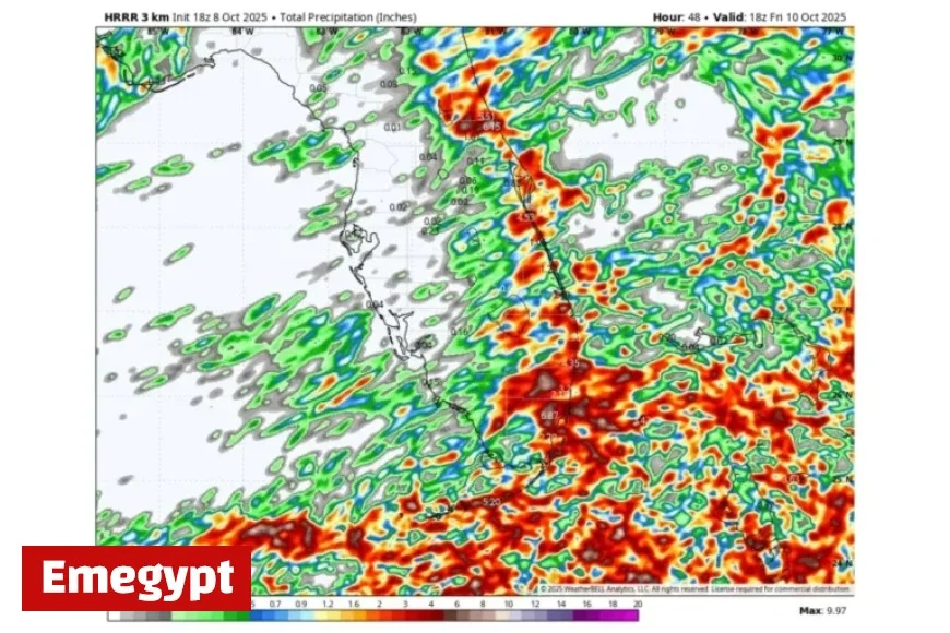
Flooding Risk Rises as Rain Intensifies Across Florida
Florida residents should prepare for significant rainfall this week, as meteorologists predict increased chances of flooding in certain regions. The National Weather Service (NWS) has issued warnings highlighting the potential impacts of this adverse weather pattern.
Focus on the East Coast: Areas at Risk
According to meteorologist Noah Bergren’s analysis shared on social media, areas extending from Miami to Daytona Beach, including Cocoa Beach, may experience rainfall of 6 inches or more by Friday noon. Meanwhile, Florida’s west coast may remain comparatively dry.
Historically, the Daytona Beach area averages around 4.85 inches of precipitation in October, while Miami typically receives 7.65 inches. This week’s forecast suggests the potential for rainfall surpassing these averages.
Weather Dynamics: Showers and Thunderstorms Expected
The NWS Miami forecast office anticipates chaotic weather on Thursday, with showers and thunderstorms likely in the afternoon and early evening. Areas affected by the heaviest downpours could face localized flooding.
Compounding these challenges are king tides, as seen earlier this week in Daytona Beach. NWS meteorologist Robert Haley explained that these high tides occur from September to January and can be exacerbated by onshore winds, leading to coastal flooding and beach erosion.
Expert Insights: What Meteorologists are Observing
- Noah Bergren emphasized the possibility of significant rainfall on Florida’s east coast, warning of potential flooding along the I-95 corridor.
- NWS Melbourne highlighted increased rain chances with gusty winds, particularly along the coastline, and cautioned about hazardous beach conditions.
- NWS Miami forecasted that showers and thunderstorms would most affect east coast areas, with midday temperatures reaching the upper 80s.
Monitoring and Response: Staying Informed
Given the potential severity of the weather, forecasts may evolve. Residents are advised to stay informed through local updates from the NWS on their website and social media outlets such as Emegypt.


