Phoenix Weather Today: Sunshine Returns After Monday’s Flash-Flood Scare
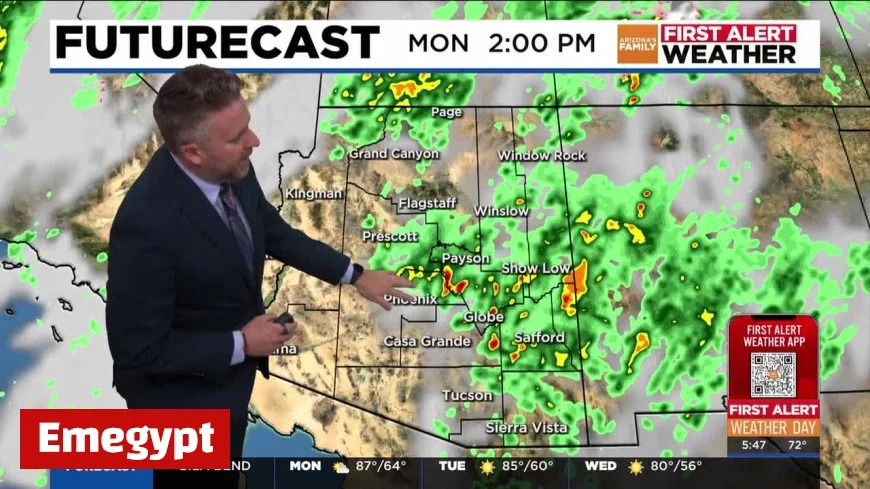
After a stormy start to the week, Phoenix weather settles into a calmer, brighter pattern today—Tuesday, October 14, 2025—with pleasant sunshine, lower humidity, and a high near the mid-80s. Monday’s slow-moving thunderstorms triggered localized flash flooding and dangerous wind gusts across parts of the Valley. Today flips the script: drier air takes hold, skies clear, and the city begins an extended stretch of quiet, seasonable days.
What to Expect Today in Phoenix
Skies trend mostly sunny as the atmosphere dries out behind yesterday’s storms. Afternoon highs hover around 85°F, with a light breeze and notably less humidity than Monday. Morning puddles and minor wash flows recede quickly, though a few slick spots may linger on shaded roads. Air quality typically improves with post-frontal ventilation, and with abundant sun you’ll feel a crisp edge early and after sunset.
Day planner:
-
8–10 a.m.: Cool and comfortable; ideal for outdoor workouts.
-
Noon–3 p.m.: Peak warmth near the mid-80s; sunscreen and hydration recommended.
-
After 6 p.m.: Rapid cooldown into the 70s, then the 60s overnight.
Recap of Monday’s Rough Weather
The Phoenix weather whiplash was real: thunderstorms pulsed over the metro on Monday, dropping heavy bursts of rain, producing pockets of flash flooding, and tossing around strong, occasionally damaging winds. As cells trained over the same areas, low-lying roads, underpasses, and dry washes filled quickly—classic Sonoran Desert hazards when short-duration downpours hit hard. If you parked along washes or commute through flood-prone corridors, build in a few extra minutes this morning in case of residual cleanup.
The Next 5–7 Days: A Dry, Comfortable Run
A stable ridge aloft expands over the Southwest through the week, delivering several days of sunny, mild weather with cool nights—prime October conditions.
-
Wednesday: Plenty of sun, highs around 80°F, a touch cooler in the evening.
-
Thursday: Sunny and seasonable near 79°F, light winds.
-
Friday: Back to around 80°F under blue skies.
-
Saturday: Slight warm-up, near 83°F; still dry.
-
Sunday: Trending warmer, mid to upper 80s with abundant sunshine.
Overnight lows dip into the upper 50s to low 60s, excellent for open-window sleeping in many neighborhoods away from busy corridors and the urban heat island.
Weather for Phoenix, Maricopa County:
Current Conditions: Light rain, 76°F (24°C)
Daily Forecast:
- Monday, October 13: Low: 66°F (19°C), High: 85°F (29°C), Description: Variable cloudiness with a couple of showers and a thunderstorm this afternoon; thunderstorms can bring flash flooding and localized damaging wind gusts
- Tuesday, October 14: Low: 63°F (17°C), High: 85°F (29°C), Description: Brilliant sunshine, pleasant and less humid; the start of an extended stretch of dry weather
- Wednesday, October 15: Low: 58°F (14°C), High: 80°F (27°C), Description: Pleasant with plenty of sunshine
- Thursday, October 16: Low: 57°F (14°C), High: 79°F (26°C), Description: Cool with plenty of sunshine
- Friday, October 17: Low: 58°F (14°C), High: 80°F (27°C), Description: Pleasant with plenty of sunshine
- Saturday, October 18: Low: 61°F (16°C), High: 83°F (28°C), Description: Pleasant with plenty of sunshine
- Sunday, October 19: Low: 62°F (17°C), High: 87°F (30°C), Description: Plenty of sun
Severe Weather Alerts:
-
Maricopa: Flash Flood Warning in effect until 4:15 PM MST. Source: U.S. National Weather Service, The National Weather Service in Phoenix has issued a
-
Flash Flood Warning for... Maricopa County in south central Arizona... Pinal County in southeastern Arizona...
-
Until 415 PM MST.
-
At 110 PM MST, trained weather spotters reported thunderstorms producing heavy rain across the warned area. Up to 0.75 inches of rain have fallen. The expected rainfall rate is 0.5 inches in 10 minutes. Flash flooding is ongoing or expected to begin shortly.
HAZARD...Life threatening flash flooding. Thunderstorms producing flash flooding.
SOURCE...Trained spotters reported.
IMPACT...Life threatening flash flooding of creeks and streams, urban areas, highways, streets and underpasses.
-
Some locations that will experience flash flooding include... Phoenix, Mesa, Chandler, Scottsdale, Gilbert, Tempe, Sun Lakes, Arizona Mills Mall, Chandler Fashion Center Mall, Arizona State University, Fiesta Mall, Tempe Marketplace, Chandler City Hall, Papago Park, Mesa Riverview Mall, Sky Harbor Airport, Downtown Mesa, Guadalupe and Firebird Lake.
This includes the following highways... AZ Route 87 between mile markers 166 and 175. AZ Route 202 between mile markers 10 and 14...and between mile markers 2 and 4...and between mile markers 48 and 49. AZ Route 101 between mile markers 50 and 59. US Highway 60 between mile markers 173 and 180. AZ Interstate 10 between mile markers 148 and 149...and between mile markers 150 and 156. AZ Route 347 between mile markers 184 and 189.
PRECAUTIONARY/PREPAREDNESS ACTIONS...
Turn around, don't drown when encountering flooded roads. Most flood deaths occur in vehicles.
Be aware of your surroundings and do not drive on flooded roads.
Please report observed flooding to local emergency services or law enforcement and request they pass this information to the National Weather Service when you can do so safely.
&&, start time: Monday, October 13, 13:10:00 UTC, end time: Monday, October 13, 16:15:00 UTC
-
Maricopa: Flash Flood Warning in effect until 4:30 PM MST. Source: U.S. National Weather Service, The National Weather Service in Phoenix has issued a
-
Flash Flood Warning for... Maricopa County in south central Arizona...
-
Until 430 PM MST.
-
At 127 PM MST, Doppler radar and automated rain gauges indicated thunderstorms producing heavy rain across the warned area. Up to 0.5 inches of rain have fallen. The expected rainfall rate is 0.5 inches in 10 minutes. Flash flooding is ongoing or expected to begin shortly.
HAZARD...Life threatening flash flooding. Thunderstorms producing flash flooding.
SOURCE...Radar and automated gauges.
IMPACT...Life threatening flash flooding of creeks and streams, urban areas, highways, streets and underpasses.
-
Some locations that will experience flash flooding include... Phoenix, Scottsdale, Tempe, Paradise Valley, Camelback Mountain, Scottsdale Airport, Downtown Scottsdale, Piestewa Peak Park, Papago Park and Desert Ridge Marketplace.
This includes the following highways... AZ Route 202 between mile markers 1 and 4. AZ Route 101 between mile markers 30 and 39. AZ Route 51 between mile markers 10 and 15...and near mile marker 9.
This includes the following streams and drainages... Salt River and Indian Bend Wash.
PRECAUTIONARY/PREPAREDNESS ACTIONS...
Turn around, don't drown when encountering flooded roads. Most flood deaths occur in vehicles.
Be aware of your surroundings and do not drive on flooded roads.
Please report observed flooding to local emergency services or law enforcement and request they pass this information to the National Weather Service when you can do so safely.
&&, start time: Monday, October 13, 13:27:00 UTC, end time: Monday, October 13, 16:30:00 UTC
- Maricopa: Severe Thunderstorm Warning in effect until 2:45 PM MST. Source: U.S. National Weather Service, ...A SEVERE THUNDERSTORM WARNING REMAINS IN EFFECT UNTIL 245 PM MST FOR MARICOPA COUNTY...
At 230 PM MST, a severe thunderstorm was located near Black Canyon City, or 8 miles north of New River, moving north at 35 mph.
HAZARD...60 mph wind gusts and quarter size hail.
SOURCE...Radar indicated.
IMPACT...Hail damage to vehicles is expected. Expect wind damage to roofs, siding, and trees.
Locations impacted include... New River and Black Canyon City Trailhead.
This includes AZ Interstate 17 between mile markers 233 and 241.
PRECAUTIONARY/PREPAREDNESS ACTIONS...
For your protection move to an interior room on the lowest floor of a building.
Continuous cloud to ground lightning is occurring with this storm. Move indoors immediately. Lightning is one of nature's leading killers. Remember, if you can hear thunder, you are close enough to be struck by lightning.
Torrential rainfall is occurring with this storm, and may lead to flash flooding. Do not drive your vehicle through flooded roadways.
&&, start time: Monday, October 13, 14:19:00 UTC, end time: Monday, October 13, 14:45:00 UTC
Tips for the Week Ahead
-
Road safety: Even with sun returning, avoid cutting across washes until they’re fully dry. Sand and debris can linger on roadway shoulders after flood events.
-
Outdoor plans: This is patio-dining, hiking, and festival weather. Early mornings offer the best combo of cool temps and clear air; carry water on trail regardless of the mild forecast.
-
Home & yard: Post-storm, clear leaves from drains and check flat roofs or shade structures for pooling or wind damage. Irrigation cycles can be trimmed back several minutes while humidity is down.
-
Allergies: Drier air and breezes can loft desert particulates; consider rinsing pollen off patios and swapping HVAC filters if it’s been a while.
Why the Pattern Turned So Fast
October in the Valley often rides the line between late-monsoon leftovers and crisp, continental air. As the storm energy shifted east, subsiding air and rising pressure moved in overhead. That combination wrings out the lingering moisture and caps off cloud growth, allowing Phoenix weather to pivot quickly from flash-flood caution to picnic-perfect skies.
Looking Slightly Beyond the Weekend
Confidence is high for continued dry weather into early next week, with temperatures edging warmer but still near seasonal norms. While the classic late-October cold front can’t be ruled out down the road, no organized storm signal dominates the near-term outlook. Expect cool mornings, sunny afternoons, and a comfortable desert diurnal swing to keep energy demand moderate.
Yesterday brought short-fuse flooding and strong storms, but today begins a sunny, less humid stretch that lasts through the weekend. Plan outdoor time liberally, watch leftover slick spots early, and enjoy a textbook week of autumn in the Sonoran Desert.
