


Intense storms unleash 400000 lightning strikes over NSW within just five hours
Intense thunderstorms over New South Wales (NSW) on Friday exhibited dramatic weather patterns, with significant hail and frequent lightning strikes reported across the region. The situation was fueled by warm, humid air mixing with unstable atmospheric conditions, creating a broad low-pressure trough.
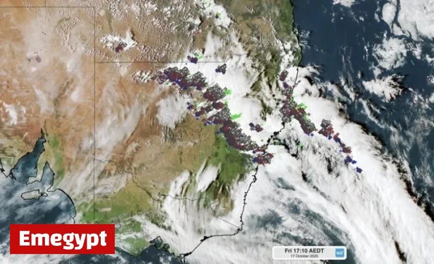
Intensity of Thunderstorms
The thunderstorms covered more than 800 kilometers, stretching from Sydney to the northern inland of the state. Early in the day, a few storm cells formed, but by the afternoon, the heat contributed to their intensification and expansion.
Lightning Strikes Recorded
Between 2 PM and 7 PM AEDT, approximately 400,000 lightning strikes were detected within a 500-kilometer radius of Dubbo. Out of these, around 70,000 strikes were identified as cloud-to-ground, while the remainder were cloud-to-cloud strikes.
Severe Weather Impacts
The thunderstorm activity resulted in strong winds, heavy rainfall, and significant hail. The largest hailstones measured up to 4 centimeters in diameter at Stuart Town, while Engadine in southern Sydney recorded hail of 3 centimeters.
Future Weather Outlook
The severe thunderstorms are expected to persist into the night, affecting parts of NSW and southern Queensland. The areas most likely to experience the most intense storms on Saturday will include northeast NSW and southeast Queensland. For the latest updates and warnings regarding this storm outbreak, it is crucial to stay informed through reliable weather sources.
- Total lightning strikes: 400,000
- Cloud-to-ground strikes: 70,000
- Largest hail size: 4 cm at Stuart Town
- Storm coverage: 800 km from Sydney to northern inland
The ongoing weather disturbances underscore the importance of monitoring severe weather alerts, as conditions remain volatile across the region.


