


Weekend Alert: Powerful Storms Threaten Dallas with Wind, Hail, and Tornado Risk
It is officially fall in Dallas, and strong storms are set to impact the area this weekend before cooler weather arrives. Residents can expect severe weather risks including wind, hail, and potential tornado threats.
Weekend Alert: Powerful Storms Threaten Dallas
Friday will bring sunny skies and strong breezes to Dallas-Fort Worth. Temperatures are predicted to reach just below 90 degrees. Some western areas may experience temperatures hitting 90 degrees. This weather is a precursor to a more volatile system arriving on Saturday.
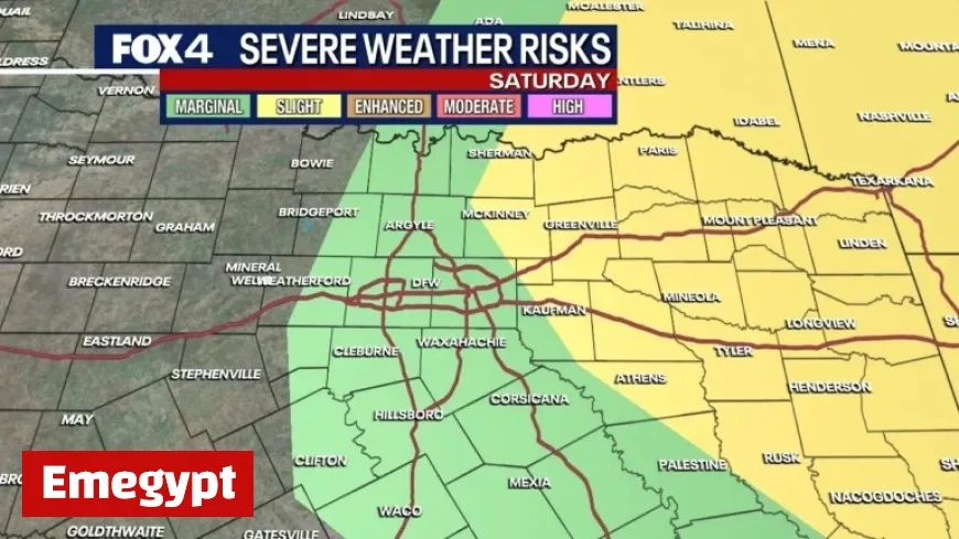
Severe Weather Risks on Saturday
The most significant weather activity is anticipated from late morning into the afternoon on Saturday. Initially, showers and storms may emerge around late morning, intensifying after noon. Between 1 p.m. and 4 p.m., residents should be prepared for the possibility of stronger storms. These storms may bring wind gusts of 55 to 60 mph and quarter-sized hail.
- Wind Gusts: Up to 55-60 mph
- Hail: Potential up to quarter-size
- Tornado Risk: Mainly east of the Metroplex
As the afternoon progresses, the storms are expected to move east, leading to a quieter evening. Overnight Saturday, a cold front will introduce very dry air, making Sunday sunny and cool.
Forecast for Sunday and Beyond
Sunday will feature clear skies with morning lows around the 50s and afternoon highs soaring to the upper 70s or near 80 degrees. These temperatures align closely with the seasonal average for this time of year.
As the week unfolds, Monday will maintain dry conditions. Temperatures will rise again, reaching 90 degrees under sunny skies. A second cold front on Monday night will cool temperatures back to the 70s on Tuesday, accompanied by sunny conditions. By mid-week, another storm system could introduce additional showers and warmer temperatures rising into the 80s by Thursday afternoon.
This information article is sourced from the National Weather Service.


