


Autumn Advances with Increasing Frequency of Cool Fronts
Scattered showers and occasional thunderstorms are expected in the Houston area today and tomorrow. While rain is much needed due to expansive drought conditions, the upcoming weather will bring periodic cool fronts, reinforcing autumn patterns. Temperatures have been notably warmer across the region, with Houston experiencing one of the top 10 warmest starts to October on record. This trend is mirrored in other places, including Chicago, Atlanta, Miami, and St. Louis, although slight changes are anticipated.
Weather Patterns and Forecast
Showers are anticipated to increase during the afternoon and decrease after sundown today. Weather conditions are projected to move more inland, providing a possibility of scattered rainfall between a quarter and half an inch in non-coastal areas.
On Saturday, rain is forecasted to begin in coastal and western regions of Houston in the morning before shifting eastwards by midday. Despite cloudy skies, significant rainfall for most of the day is unlikely.
Cool Fronts on the Horizon
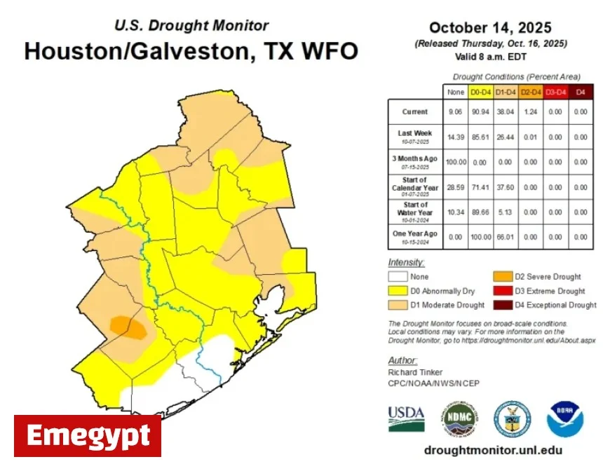
A new temperature sensor has been installed at Bush Airport to monitor Houston’s temperatures more accurately, aiming to resolve previous measurement discrepancies. Drought now impacts nearly 40% of the Houston area, a marked increase from the previous week’s data.
A mild cold front is expected to pass on Sunday morning. This dry passage will slightly lower temperatures and humidity. Sunday’s weather will be breezy with highs in the upper 80s. Though a wildfire risk exists, it remains consistent with previous autumn days. Monday’s weather should bring clear skies and pleasant temperatures.
Long-term Outlook
A reinforcing front is likely on Tuesday night, maintaining comfortable conditions with upper 80s as highs and morning lows in the 50s and 60s. Later in the week, a weaker cold front is expected, with a stronger autumn front predicted around Halloween. This suggests potential for celebrating fall’s arrival soon.


