


Expect Heavy Downpours and Gusty Winds During Monday Morning Commute
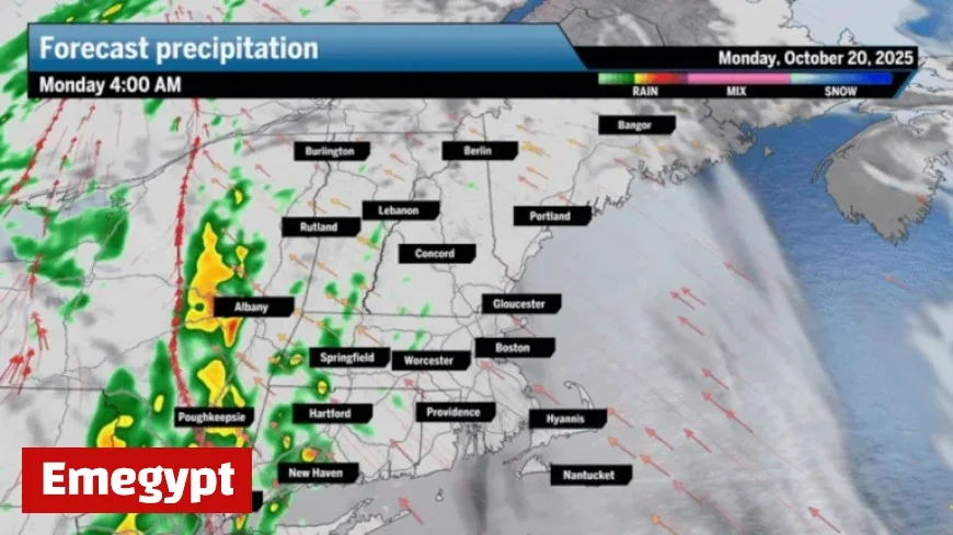
On Monday morning, expect heavy downpours and gusty winds across New England. A cold front is moving into the region, bringing a significant amount of rain during the morning commute. The storm is expected to impact Central and Western Massachusetts first, arriving in the Greater Boston area between 9 a.m. and 11 a.m.
Weather Forecast Overview
As the cold front approaches, rainfall will be accompanied by embedded thunderstorms. Up to an inch of rain is possible, which may lead to brief street flooding. While the storm is not classified as severe, it will certainly draw attention with its thunder and downpours.
Wind Conditions
Gusty winds are forecasted, reaching speeds of up to 35 mph. This southerly flow will increase temperatures into the upper 50s and mid-60s, marking the day’s highs before a cooler air mass arrives in the afternoon. Although power outages might occur due to wind gusts, most residents are expected to maintain service.
Coastal Flood Advisory
A coastal flood advisory is in effect for southern Rhode Island and the South Coast of Massachusetts until 11 a.m. This advisory indicates potential minor splash-over during high tides, with minimal impacts anticipated beyond that.
Regional Impact and Conditions
- Greater Boston: Expect rain and scattered thunderstorms in the morning with temperatures in the 60s, falling later in the day.
- Central and Western Massachusetts: Showers will occur during the morning commute, transitioning to partial clearing by evening.
- Southeastern Massachusetts: Showers and gusty winds will dominate Monday, with temperatures reaching the upper 50s to low 60s.
- Rhode Island: Breezy conditions with showers and heavy downpours are expected, with temperatures in the 50s to low 60s.
- New Hampshire: Rain and heavy downpours alongside windy conditions are forecasted, with temperatures in the low to mid-60s.
Looking Ahead
Following the storm, Tuesday is expected to bring clear skies and mild temperatures in the mid-60s, above the seasonal average. Another system is anticipated to arrive on Wednesday, bringing additional showers. As the week progresses, temperatures will drop into the 50s, aligning with typical October weather.
Be prepared for a potentially disruptive morning commute and keep an eye on changing weather conditions throughout the day.


