


Victoria Weather Warnings: Damaging to Locally Destructive Winds Set to Batter Melbourne and Much of the State Today
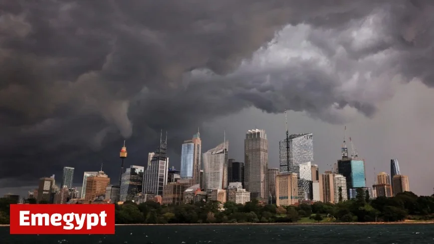
A powerful cold front racing across southern Australia is triggering Victoria weather warnings for damaging winds, with locally destructive gusts possible along exposed coastal headlands and higher terrain. Melbourne is in the warning area, with a sharp wind shift and squally showers expected through the afternoon and evening on Wednesday, 22 October.
Melbourne Weather Warning: What to Expect and When
-
Peak risk window (Melbourne): Late morning through late afternoon, easing overnight.
-
Wind profile: North to northwesterly 25–40 km/h, turning westerly 40–60 km/h as the front crosses, with damaging gusts possible during and after the change.
-
Weather mix: Cloudy with showers, the chance of a thunderstorm in the afternoon/early evening. Sudden squalls can briefly push gusts well above mean speeds.
-
Impacts: Downed branches, scattered power outages, hazardous driving on elevated/bridge sections, and rough conditions on the Bay and coastal waters.
Districts in the Firing Line
Damaging wind gusts are expected across a broad swath of Victoria, including the Central (Melbourne), South West, West and South Gippsland, North Central, Northern Country, North East, Mallee, Wimmera, and East Gippsland forecast districts.
Locally destructive gusts are most likely on the southwest coast and alpine/high ground, where terrain and exposure amplify the flow.
Indicative Timeline (Today)
| Period | Melbourne & Central | Southwest Coast & Ranges | Gippsland & Northeast |
|---|---|---|---|
| Morning | NW winds freshening; first showers | Damaging gusts beginning | NW winds strengthening |
| Midday–Afternoon | Frontal passage: wind turns W and peaks; squally showers/thunder | Highest risk of locally destructive gusts on headlands/ridges | Damaging gusts extend east; storm risk inland |
| Evening–Overnight | Winds gradually easing; lingering showers | Gradual easing after sunset | Gusty at times; easing later tonight |
Timing varies suburb to suburb; strongest bursts occur with the change and any thunderstorms.
Travel, Power and Marine Risks
-
Roads: High-sided vehicles vulnerable on elevated roads and bridges; expect debris and sudden crosswinds.
-
Power: Isolated to scattered outages possible where branches fall on lines; charge devices and keep torches ready.
-
Boating: Gale-force conditions possible on coastal waters; short, steep seas on Port Phillip and Western Port during the change. Consider delaying departures.
Practical Steps to Take Now
-
Secure loose items: Outdoor furniture, trampolines, umbrellas, construction materials.
-
Park smart: Keep cars clear of large trees and powerlines.
-
Plan trips: If you must drive during the peak window, slow down and allow extra braking distance.
-
Home prep: Close windows on the windward side; clear gutters and drains to reduce overflow with squally showers.
-
Storm safety: If thunder is heard, move indoors; avoid using corded devices and stay clear of flooded low spots.
Why This Event Is High-Impact
This setup combines very strong pre-frontal northwesterlies with a vigorous westerly change, squeezing the pressure gradient over Victoria. Add embedded thunderstorms and you get brief, intense downbursts on top of already-strong gradient winds—enough to push gusts into damaging territory across urban areas, with pockets of more severe gusts in the state’s windiest locales.
Quick City/Region Snapshots (Today)
-
Melbourne: Showers, damaging winds possible; NW 25–40 km/h turning W 40–60 km/h early afternoon; storm chance.
-
Geelong–Surf Coast–Otways: Highest exposure; risk of locally destructive gusts on headlands and ridges.
-
Ballarat–Bendigo–Shepparton: Damaging gusts possible with the change; brief heavy showers or a storm.
-
Latrobe Valley–West & South Gippsland: Damaging winds likely; hazardous coastal conditions.
-
Alpine areas: Strong to gale-force winds; whiteout conditions possible in showers.
Stay Informed, Stay Safe
-
Monitor official state warning summaries and local emergency updates throughout the day; warnings can be upgraded, expanded, or cancelled as the system moves.
-
Enable emergency alerts on your phone.
-
For life-threatening situations, call your local emergency number immediately.
A statewide wind event is underway. Melbourne and much of Victoria should plan for damaging wind gusts today, with locally destructive winds most likely on exposed coasts and higher terrain. Conditions ease tonight, but the most hazardous window spans late morning to late afternoon—secure property now and adjust travel plans accordingly.


