


Houston Prepares for Severe Cold Front: Heavy Rain and Flood Risk Saturday
A flood watch is in effect for Southeast Texas, set to last from tonight until Sunday morning. The region anticipates total rainfall ranging from 2 to 4 inches, with some isolated areas potentially receiving up to 6 inches. This weather event poses a significant risk of street flooding, particularly in locations that have recently experienced dry conditions.
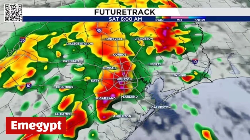
Upcoming Severe Cold Front and Rain Forecast
Friday will present warmer weather, with temperatures expected in the mid-80s. However, this will give way to stormy conditions on Saturday. Residents are advised to secure loose items in their yards as strong storms are predicted to move in early Saturday morning.
Storm Timeline
- Early Saturday Morning (4 AM – 7 AM): The first wave of storms will impact the area, with Houston expecting heavy rain around 6 AM.
- Mid-Morning (8 AM): The initial storm line will move off the coast, leading to improvement in conditions.
- Afternoon (5 PM): A second round of storms will develop with the arrival of the cold front and could intensify.
- Evening (9 PM – 11 PM): Additional storms are forecasted to reach Houston.
- Late Night (1 AM Sunday): Storms are expected to clear the area, ending the severe weather threat.
Flash Flood Watch
Due to the expected heavy rainfall, the National Weather Service has issued a 2 out of 4 flash flood threat for Saturday. Residents should remain alert, especially given a low risk of tornado activity. It is critical to keep mobile devices charged and notifications enabled for emergency alerts.
Burn Ban Information
Despite the rain, burn bans remain in effect across much of the region, with only a few counties not impacted. Residents should exercise caution, avoiding activities that could ignite fires. Key safety tips include:
- Secure tow chains to prevent sparks while driving.
- Avoid leaving fires unattended.
- Do not park over tall grass to prevent fires.
- Dispose of lit cigarettes responsibly.
Extended Weather Outlook
Next week, a stronger cold front is expected to bring cooler temperatures, with highs in the 70s and lows dropping into the 50s, just in time for Halloween festivities.


