


Heavy Rains Expected This Weekend, Enjoy Fall Fun with 60s Highs
Heavy rains are predicted this weekend as Houston prepares for two separate storm rounds. The first is expected early Saturday, and the second may arrive by Saturday evening. Despite these anticipated storms, organizers plan to continue with their Fall Day celebration at Midtown Park, running from 10 AM to noon CT.
Fall Day Celebration Details
Saturday’s Fall Day event is set against the backdrop of changing weather conditions. Early rains are expected to clear up by the time festivities begin. Temperatures during the event are projected to be in the low 70s, with some cover available in case of scattered showers.
Weather Forecast for Friday
- Mostly clear skies in the morning.
- Clouds will increase as moisture levels rise.
- Scattered showers may occur south and west of Houston later in the day.
- Maximum temperatures in the low to mid-80s.
- Breezy conditions with winds up to 25 mph.
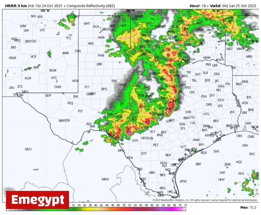
Storm Timing and Impacts
As the night approaches, a powerful line of thunderstorms is expected to move toward Houston from Central Texas. Timing details indicate:
- Arriving in College Station between 1 AM and 3 AM.
- Reaching central Houston from 3 AM to 6 AM.
- Coastal areas impacted between 6 AM and 8 AM.
This storm is projected to deliver 1 to 2 inches of rain, with potential localized heavier amounts, and the risk of damaging winds and possibly an isolated tornado.
Second Round of Storms Expected
Later Saturday, after the initial storms pass, a second storm system may develop northwest of Houston. This system could bring more severe weather, including hail, during the evening hours. Overall, both storm rounds are forecasted to accumulate 2 to 4 inches of rain.
Safety Precautions
While widespread flooding is unlikely due to dry soils, residents are advised to exercise caution on the roads, especially at night when visibility may be reduced. There exists a slight risk of severe weather through Saturday evening.
Sunday and Next Week’s Outlook
Sunday is expected to start with lingering showers before clearing up later, with high temperatures around 80 degrees. The upcoming week will see slightly warmer days on Monday and Tuesday, before a new front brings cooler air.
Expected Temperature Shifts
- Highs in the low to mid-80s on Monday and Tuesday.
- A transition to highs in the 70s, possibly dropping to the 60s on Thursday.
- Nighttime temperatures may fall into the 50s.
October 31, Halloween, is predicted to be clear and pleasantly cool, offering ideal conditions for trick-or-treaters in Houston.


