


Severe Weather Strikes Houston; Brief Lull Before More Rain Tonight
Severe weather recently impacted Houston, causing power outages, potential tornado threats, and heavy rainfall. On Sunday night into Monday morning, the region braced for significant thunderstorms, including winds reaching up to 60 mph and possible hail.
Current Weather Conditions and Warnings
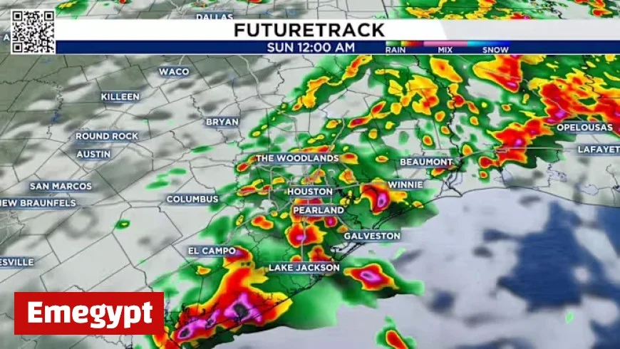
As of 8 PM, thunderstorms and scattered showers are present across Southeast Texas, preceding a cold front moving toward the area. The main line of storms is positioned northwest of Houston and is expected to advance toward the city.
Timeline of Weather Events
- 8 PM: Storms located NW of Houston.
- 10 PM: Storm line moving SE across much of Houston.
- Midnight: Storms expected to push south of I-10.
- 2 AM: Anticipated departure of storms off the coast.
Areas north of Houston might experience heavy rainfall. Given that the region has been dry for weeks, rapid rainfall can lead to street flooding. A flash flood watch has been advised with a threat level rated at 2 out of 4, indicating a high risk for localized flooding.
Tornado Threat and Safety Measures
The potential for tornadoes persists. Residents are reminded to keep their phones volume up and ensure alert notifications are activated. This precaution will aid in receiving timely warnings throughout the night.
Fire Hazards and Burn Bans
Despite the rain, burn bans remain in effect in many counties due to dry conditions. Consequently, authorities urge the public to avoid activities that could spark fires. Adhering to safety measures can prevent accidental ignitions:
- Avoid leaving fires unattended.
- Secure tow chains to prevent sparks.
- Do not drive or park on dry grass.
- Dispose of cigarettes responsibly.
Looking Ahead: The Extended Forecast
Forecast indications show the strongest cold front of the season approaching next Tuesday. This weather change will lead to temperatures in the 70s and lows around the 50s, clearing the way for a bright Halloween week ahead.
Residents are encouraged to report any significant weather occurrences by sharing photos and videos with local news platforms to keep the community informed.


