


Storm Threat Persists Through Sunday Morning
As a significant weather system approaches Baton Rouge, the threat of strong to severe thunderstorms remains a concern. This warning extends overnight into Sunday morning, with conditions expected to improve by the afternoon.
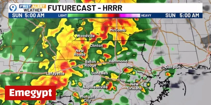
Storm Threat Through Sunday Morning
A cold front is set to trigger widespread showers and thunderstorms. While the severe weather threat is classified as low, there remains a possibility of one or two intense storms developing. Meteorologists indicate that all types of severe weather could emerge.
Timeline and Impact
The bulk of these storms is anticipated to arrive before sunrise on Sunday. A significant amount of rain, estimated at 1 to 2 inches, could fall, increasing total weekend rainfall to between 1.5 and 3 inches. This rainfall may result in nuisance flooding, especially on poorly drained roads.
Weather Improvement by Afternoon
Fortunately, the weather is expected to improve by late Sunday morning. For those attending events like ‘Boo at the Zoo,’ this change brings welcome news. Although a few stray showers may linger, most areas should remain dry. Afternoon temperatures are projected to stay in the comfortable 70s.
Looking Ahead Towards Halloween
As the new work and school week begins, dry weather is anticipated on Monday, with similar conditions on Tuesday. However, another cold front may generate showers from Tuesday into Wednesday. This upcoming front is unlikely to produce significant rain, but it will usher in much cooler temperatures.
- Temperatures could drop by 10 to 15 degrees, leading to lows in the 50s and highs in the 60s.
- These cooler conditions are expected just in time for Halloween festivities.
Residents should prepare for changing weather conditions as the storm threat persists but will ultimately give way to a drier and cooler climate.


