


Tropical Storm Melissa Explodes Into Catastrophic Category 5 Hurricane Aiming Directly at Jamaica
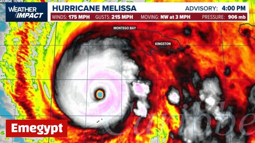
Tropical Storm Melissa has intensified into a Category 5 hurricane and is closing in on Jamaica today with winds near 175 mph, torrential rain, and life-threatening storm surge. Officials warn the system is large, slow-moving, and capable of historic damage across multiple parishes as the eyewall moves over or very near the island through the afternoon and evening. With rainfall totals measured in feet and surge pushing seawater well inland, the storm presents Jamaica’s most dangerous cyclone threat in modern records.
When Melissa Will Hit Jamaica
The highest-impact window is late morning through late afternoon (local time) as the eyewall crosses the island from south to north. Tropical-storm conditions arrive and expand earlier, then escalate rapidly as the core nears the coast.
Approximate timing by region (local):
-
South-central (St. Elizabeth, Manchester): 10:30 a.m.–1:00 p.m.
-
Clarendon, St. Catherine: 11:00 a.m.–2:00 p.m.
-
Kingston & St. Andrew / Port Royal corridor: 11:30 a.m.–2:30 p.m.
-
St. Thomas: Noon–3:00 p.m.
-
Central north (St. Ann, Trelawny): 1:00–4:00 p.m.
-
Northeast (St. Mary, Portland): 2:00–5:00 p.m.
-
West/northwest (Hanover, St. James, Westmoreland): 2:00–6:00 p.m.
Calm conditions near midday may indicate the eye—not the end. Backside winds will return suddenly and from the opposite direction.
Key Hazards for Jamaica as Hurricane Melissa Arrives
-
Extreme wind damage: Sustained Category 5 winds can strip roofs, collapse poorly anchored structures, and topple concrete poles. Debris will become airborne in the eyewall.
-
Storm surge 10–13 ft in spots: Highest along south-coast inlets and low-lying corridors near and east of the landfall point, then risk shifts to portions of the north coast as the core exits. Saltwater intrusion may affect hospitals and water infrastructure near the shoreline.
-
Catastrophic rainfall and landslides: 15–30 inches are expected widely with localized maxima far higher in mountainous terrain. Rapid rises on rivers and gullies will trigger life-threatening flash floods and landslides, with crests often peaking after the worst winds.
-
Power and communications outages: Long-duration blackouts are likely as transmission lines and access roads suffer damage, delaying restoration.
Government Response and Evacuations
Hundreds of shelters are open nationwide, with evacuation orders in flood-prone coastal zones and communities near river crossings. Airports and major ports are closed pending post-storm inspections. Health facilities have repositioned patients above potential surge levels and staged generators; emergency teams caution that rescues may be suspended during peak winds until conditions are safe.
Why Tropical Storm Melissa Became a Monster Hurricane
Melissa’s rapid intensification over exceptionally warm Caribbean waters and low wind shear allowed a compact tropical storm to balloon into a large, slow Category 5. Jamaica’s steep terrain amplifies rainfall via orographic lift, while the storm’s sluggish pace prolongs exposure to destructive winds and repeated rainbands. This combination—slow speed + mountainous topography + extreme intensity—creates a worst-case scenario for inland flooding and structural fatigue.
Parish Readiness: Last-Minute Actions That Still Help
-
Shelter now in a small, interior room on a lower floor above flood level.
-
Stay off roads. Do not attempt to cross fords or bridges once squalls begin; water depth and current can change minute to minute.
-
Elevate essentials (documents, electronics, medications).
-
Secure doors and interior hallways to reduce pressure loads if windows fail.
-
Operate generators outdoors only and far from openings to prevent carbon monoxide poisoning.
What Comes After Jamaica: Track Toward Cuba and the Bahamas
After crossing Jamaica, Hurricane Melissa is expected to remain a major hurricane while moving toward eastern Cuba later tonight into Wednesday, then the southeastern Bahamas and Turks and Caicos. Exact intensity will depend on land interaction, but the storm’s size and moisture envelope mean widespread impacts continue well beyond the center. Travel disruptions, port closures, and prolonged utility outages are likely across the region.
The Next 24–72 Hours in Jamaica
-
0–24 hours: Search-and-rescue begins as winds ease, prioritizing trapped residents, medical transfers, and critical infrastructure checks.
-
24–48 hours: Primary corridors between parishes are cleared; assessments of bridges, hillside roads, and coastal defenses determine where access requires air or sea support.
-
48–72 hours: Power restoration focuses on backbone lines; localized distribution repairs follow as debris removal opens neighborhoods. Agricultural losses (bananas, sugar, smallholder crops) and tourism infrastructure damage will become clearer.
Tropical Storm Melissa has evolved into a Category 5 hurricane and is set to deliver Jamaica’s peak impacts from late morning through late afternoon today, with catastrophic wind, surge, and flooding risks. Treat the eye’s calm as a trap, remain in shelter until an official all-clear is issued, and prepare for an extended period of outages and difficult travel even after the center moves away. This is a fast-changing, high-end emergency—final preparations must end now.


