


Hurricane Melissa track today: Category 5 rakes Jamaica, aims for eastern Cuba, Hispaniola, the Bahamas, then near Bermuda
Hurricane Melissa’s track turned catastrophic on Tuesday as the storm made landfall in western Jamaica with winds near 185 mph, one of the most powerful landfalls ever recorded in the Atlantic basin. The hurricane is now tracking north-northeast across Jamaica and into the Windward Passage, with life-threatening wind, storm surge, and extreme rainfall. While gradual weakening is likely as Melissa interacts with land and increasing wind shear later this week, the system’s large wind field and prolific moisture will keep impacts severe well beyond the core.
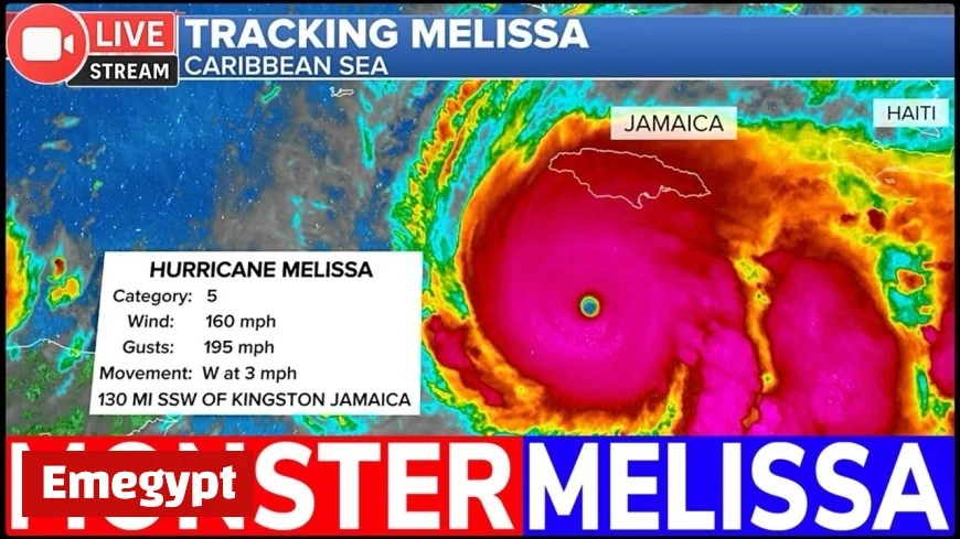
Latest position and movement for Hurricane Melissa’s track
As of mid-afternoon Tuesday (3 p.m. ET / 7 p.m. GMT), Hurricane Melissa’s eye was crossing western Jamaica, moving north-northeast around 8 mph. Gusts well over 100 mph and destructive storm surge have been battering the island’s western and northern coasts. A slow turn to the northeast is expected tonight, placing the core near or just east of the Windward Passage between Cuba and Hispaniola late tonight into Wednesday.
Key hazards today and tonight
-
Wind: Catastrophic damage likely where the eyewall crosses western and northern Jamaica. Hurricane-force winds extend outward several dozen miles.
-
Rainfall and flooding: 15–30 inches common in southern and central Jamaica with localized totals up to 40 inches, triggering flash floods and landslides.
-
Surge: Dangerous, rapidly rising water levels along north- and west-facing shores of Jamaica, shifting toward eastern Cuba and southern Hispaniola as the track lifts northeast.
Recent updates indicate the center is wobbling with terrain interaction; details may evolve.
Short-term forecast: Hurricane Melissa track through Wednesday (ET/GMT)
-
Tonight (Tue, Oct 28): Core lifts off northern Jamaica and approaches the Windward Passage. Hurricane conditions possible along eastern Cuba’s Guantánamo–Holguín corridor and in southwest Haiti.
-
Wednesday (Oct 29): Track trends northeast along or just north of eastern Cuba and southern Hispaniola. Bands with destructive gusts and torrential rain spread into the Dominican Republic. Seas build rapidly across the Turks and Caicos.
Expected impacts Wednesday
-
Eastern Cuba & Hispaniola: Significant flash flooding, mudslides in mountainous terrain, and power outages.
-
Marine/aviation: Dangerous seas and near-zero visibility in squalls across the Windward Passage and adjacent Caribbean waters.
Medium-range outlook: Hurricane Melissa track toward the Bahamas and near Bermuda
From Wednesday night through Thursday, guidance clusters on a northeast acceleration that steers Melissa into or near the southeastern then central Bahamas. While some weakening is probable, the storm’s envelope remains large, capable of producing hurricane conditions well away from the center.
-
Thursday (Oct 30): Core likely near the central Bahamas. Widespread coastal flooding, damaging winds, and 6–12 inches of rain with locally higher amounts.
-
Late Thu–Fri (Oct 30–31): Track continues northeast over the open Atlantic. Melissa could pass near Bermuda late Friday into early Saturday, with the exact distance dictating whether hurricane-force winds reach the island. Cooler waters and shear should promote a gradual weakening trend, but a large wind and swell footprint will persist.
Note: Track and intensity beyond 48 hours carry higher uncertainty and may shift with each advisory.
Hurricane Melissa timing snapshot (US ET / UK GMT)
-
Jamaica (ongoing): Peak impacts through Tuesday evening; dangerous flooding continues into Wednesday.
-
Eastern Cuba & Southern Hispaniola: Worst conditions late Tuesday night through Wednesday.
-
Turks & Caicos / Southeastern–Central Bahamas: Deteriorating weather Wednesday night; peak impacts Thursday.
-
Bermuda: Swells build Thursday; closest approach late Friday into early Saturday (timing subject to change).
Preparedness and safety for areas along Melissa’s projected path
-
Evacuations & shelters: Follow local orders immediately. If you live in surge-prone zones, move to higher ground before bands intensify.
-
Power & water: Expect prolonged outages. Charge devices, store at least three days of water (1 gallon per person per day), and secure medications.
-
Travel & marine: Ports and airports in the western and central Caribbean may suspend operations. Mariners should avoid the Windward Passage and Bahamas waters for several days.
-
After the eye: Do not venture out if winds drop suddenly; the back side of the eyewall can return with violent gusts minutes later.
What could change next in Hurricane Melissa’s track
Two variables will drive the forecast beyond midweek:
-
Speed of the northeast turn. A quicker turn would spare parts of eastern Cuba and southern Hispaniola the absolute worst winds but expand heavy rain farther east sooner.
-
Rate of weakening. Interaction with land and increasing shear should erode peak winds, but Melissa’s size means dangerous surf, rip currents, and coastal flooding will extend far from the center, including along exposed Atlantic coasts well into the weekend.
Hurricane Melissa’s track has shifted into a destructive, history-making passage across Jamaica and then northeast through the Caribbean toward the Bahamas, with a potential close pass near Bermuda late week. Communities in the path should treat all official warnings with urgency. New advisories will refine the trajectory and timing through the next 6–24 hours.


