


Tropical Storm Melissa becomes a historic Category 5 hurricane in Jamaica: catastrophic winds, surge and floods as system crosses the island
Hurricane Melissa roared ashore in western Jamaica on Tuesday, rapidly intensifying from tropical-storm origins into a Category 5 behemoth that delivered some of the strongest winds ever recorded at landfall in the Atlantic. The eye came ashore near New Hope in the island’s west, driving life-threatening storm surge, destructive gusts and torrential rain into coastal and mountainous communities. Officials urged residents to shelter in place until emergency crews can reach worst-hit areas.
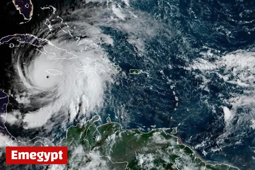
Hurricane Jamaica: where Melissa is now and where it’s going
As of Tuesday evening, Melissa’s core continued to grind across western and central parishes, with the most dangerous eyewall winds and surge along the south and west coasts. Interaction with Jamaica’s high terrain is expected to trigger gradual weakening, but the hurricane will remain extremely dangerous through the night. The forecast track carries Melissa north-northeast toward waters between southeastern Cuba and the Bahamas late Wednesday into Thursday, keeping a wide envelope of hurricane-force and tropical-storm-force winds over the Caribbean and adjacent Atlantic. Interests in Cuba, the Turks and Caicos, and the Bahamas should finalize preparations and monitor local warnings.
Wind, surge and rain: the three major threats from Melissa
-
Wind: Sustained winds near the eyewall were estimated around 185 mph (295 km/h) at landfall, capable of extensive structural damage, snapped power poles, and long-duration outages. Exposure and elevation will make a big difference: ridgetops and high-rise corridors can see markedly stronger gusts.
-
Storm surge: Along south- and west-facing bays, surge heights of 10–13 feet (3–4 m) above normally dry ground are possible near and east of the landfall point, with dangerous wave action. Low-lying roads may be impassable for days where debris piles on top of saltwater flooding.
-
Rainfall and flooding: Bands wrapping into the circulation are producing extreme totals. Widespread double-digit inches are likely, with localized amounts pushing well over 20 inches (500+ mm) in mountainous terrain. Flash flooding, landslides and debris flows are a top-tier hazard tonight into Wednesday, especially where saturated slopes meet steep ravines.
Impacts across Jamaica: power, transport and communications
Initial reports point to widespread power outages across multiple parishes, with transmission corridors and feeder lines damaged by fallen trees and poles. Mobile and internet services are intermittent in the hardest-hit districts, particularly where the eyewall crossed the coast. Several roads are blocked by downed vegetation and structural debris; landslide-prone corridors in the interior may remain closed even after winds ease due to ongoing slope instability. Airports suspended operations ahead of landfall; decisions on reopening will hinge on daylight assessments of runway debris, navigational aids and terminal damage.
Safety guidance for tonight and Wednesday
-
Shelter from wind: Stay in interior rooms on the lowest floor, away from windows. Use mattresses or helmets to protect from flying debris if your building begins to fail.
-
Flood awareness: If water rises inside, move to higher levels quickly. Never enter floodwaters; contamination, hidden currents and downed lines make them lethal.
-
After the eye: Conditions can briefly improve as the calm center passes, then deteriorate rapidly when the back eyewall arrives—do not venture out until officials say it is safe.
-
Power hazards: Treat all lines as live. Do not run generators indoors or in partially enclosed spaces. Ventilate to prevent carbon monoxide poisoning.
Tropical Storm Melissa to Hurricane Melissa: how it intensified so quickly
Melissa’s explosive strengthening was fueled by exceptionally warm sea-surface temperatures, high ocean heat content and periods of low vertical wind shear—conditions that enable compact cores to tighten rapidly. The storm developed a tiny, intense eyewall with very low central pressure (near the upper 800s millibars), a signature of the most violent Atlantic cyclones. Terrain interaction over Jamaica will cause some weakening, but the circulation is large enough to maintain dangerous winds and prolific rainfall through Wednesday.
What’s next beyond Jamaica
-
Cuba: Western and central Cuba face increasing risk of hurricane-force gusts, heavy rain and dangerous surf late Wednesday. Evacuation and sheltering plans are already in motion in surge-exposed communities.
-
Bahamas and Turks & Caicos: The system is expected to retain significant strength as it approaches from the southwest. Storm surge, damaging winds and flooding rain are possible into late week; mariners should avoid all routes near the forecast path.
-
Long-range: Guidance suggests Melissa could bend more north or northeast afterward, keeping dangerous seas over the western Atlantic and creating a swell event for parts of the U.S. East Coast later this week. Exact impacts there depend on the post-Jamaica structure.
Key takeaways for Jamaica tonight
-
Category 5 winds and catastrophic gusts in and near the eyewall, with destructive surge on south- and west-facing coasts.
-
Life-threatening inland flooding and landslides overnight and into Wednesday, especially in mountainous parishes.
-
Prolonged, possibly multi-day power and communications outages in the hardest-hit zones.
-
Remain sheltered until authorities issue an all-clear; roads and bridges will require inspection before travel resumes.
Tropical Storm Melissa’s transition into a Category 5 hurricane at Jamaica ranks as a historic event. The island faces a dual crisis of wind destruction and water hazards tonight, with recovery complicated by blocked roads and widespread outages. Conditions will slowly improve after the core moves away, but the danger persists—stay put, stay informed, and keep life-safety first.


