


N.J. Forecast: Thunderstorms, Heavy Rain, 50 mph Winds Expected Today
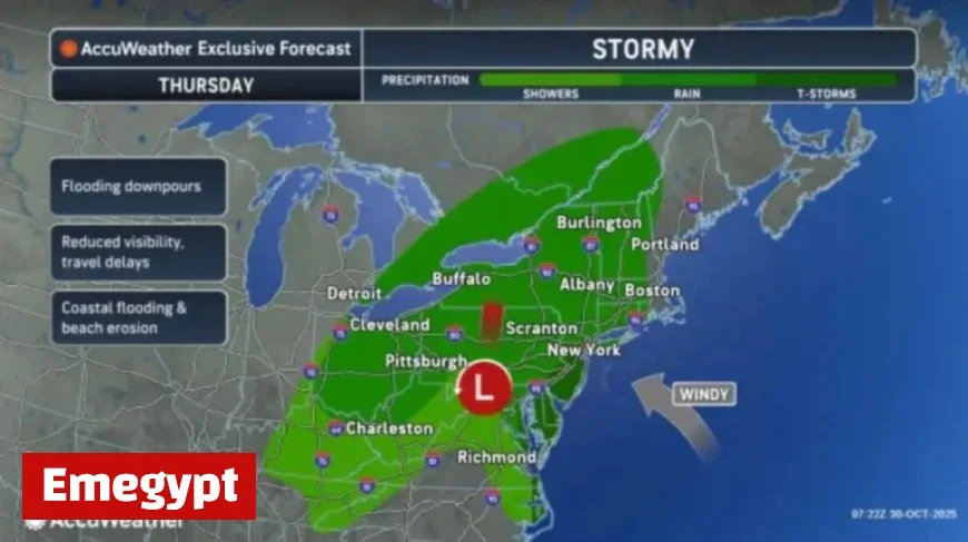
A powerful storm is set to impact New Jersey today, bringing thunderstorms, heavy rain, and winds reaching up to 50 mph. Residents can expect a range of weather conditions as the storm progresses throughout Thursday.
N.J. Forecast: Thunderstorms, Heavy Rain, 50 mph Winds Expected Today
The National Weather Service has issued warnings as a strong storm system moves through the state. Rain is anticipated to begin this morning, intensifying during the afternoon and evening.
Weather Hazards and Impacts
- Rainfall: Most areas can expect between 1 to 2 inches, with some localized regions potentially receiving up to 3 inches.
- Thunderstorms: Isolated severe thunderstorms could lead to damaging wind gusts and even brief tornadoes.
- Wind Gusts: Expect gusts of 30-40 mph inland and 40-50 mph along the Jersey Shore.
- Coastal Flooding: Minor flooding is forecasted during high tide cycles along the Jersey Shore and Delaware Bay.
Evening Conditions for Halloween
As the day progresses, high winds will persist into Halloween night, coinciding with trick-or-treating hours. While the rain is expected to taper off, wind gusts will remain significant, which could impact outdoor activities.
Post-Storm Outlook
On Friday, winds will shift to the west, with continued gusts of 40-50 mph possible. This shift could contribute to additional tree damage and power outages. The temperature is anticipated to cool, hovering in the mid to upper 50s.
Looking ahead, the weekend will see improving weather conditions. Saturday will still experience breezy winds but will start to calm as high pressure builds. Highs will range from mid-50s to around 60 degrees. Sunday promises to be even more tranquil, with partly sunny skies.
Next Week’s Weather
Entering early next week, high pressure is expected to dominate, although a cold front may approach by Tuesday. Current forecasts indicate potential systems developing off the East Coast, but they are likely to remain south of New Jersey.
Residents should be prepared for chilly overnight temperatures, primarily in the 30s and 40s, with some areas, particularly in the Pine Barrens, at risk of freezing temperatures over the weekend.
Stay updated with Emegypt for the latest weather advisories and forecasts as this storm unfolds.


