


Severe Storm Threat Looms Over W. Oregon and SW Washington Wednesday
The Pacific Northwest is bracing for severe weather, particularly in Western Oregon and Southwestern Washington. The National Weather Service (NWS) in Portland has issued a Special Weather Statement highlighting the potential for severe thunderstorms.
Severe Storm Threat for W. Oregon and SW Washington
The forecast indicates a small risk of severe thunderstorms, with the possibility of waterspouts, funnel clouds, or even tornadoes. Stronger thunderstorms could generate damaging wind gusts up to 60 mph.
Weather Predictions and Alerts
- Date of Notice: Current weather warnings are in effect for today.
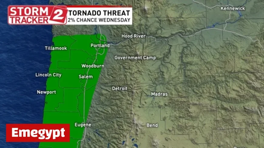
- Tornado Probability: There is a 2% chance of a tornado occurring within 50 miles of key cities, including most areas of the Portland metro and the Oregon Coast.
- Risk Level: The Storm Prediction Center categorizes the risk as Marginal, rated at 1 out of 5.
Rhonda Shelby, a meteorologist with Storm Tracker 2, noted that despite the low risk level, conditions could still lead to isolated severe weather events. She urged residents to remain vigilant and weather-aware throughout the afternoon.
Safety Precautions
Residents are advised to seek shelter in an interior room on the lowest floor if a funnel cloud or tornado is spotted, or if a Tornado Warning or Severe Thunderstorm Warning is issued. Heavy rain, sudden wind gusts, and lightning are expected as the storm system progresses.
- Action Items:
- Monitor local forecasts
- Download the Storm Tracker 2 Weather App for real-time updates
- Know your safe spots in case of severe weather alerts
A Tornado Warning is currently in effect for parts of Pacific County in Washington until 5:15 p.m., as per NWS announcements. Stay informed and take precautions as severe weather threatens the region.


