


Charlotte Faces Freeze Warning as Wind Chills Drop to 16 Degrees
A significant cold front is set to impact the Charlotte region with wind chills plummeting to 16 degrees. The National Weather Service (NWS) has issued a freeze warning effective from 8 p.m. on Monday until 9 a.m. on Tuesday. This warning is due to a forecasted temperature drop of 20 degrees within a few hours.
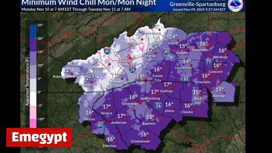
Cold Snap Details
Along with the frigid temperatures, gusts of wind reaching 30 mph and even light snow flurries are anticipated. The NWS has indicated the possibility of snow showers before 11 p.m. Monday, followed by occasional flurries until 1 a.m. Tuesday. However, significant snow accumulation is not expected.
Temperature and Conditions
- Expected low temperature: 27 degrees
- Wind chill in higher elevations: as low as -12 degrees
- Gusts reported: over 50 mph at Grandfather Mountain
- 20% chance of precipitation
Forecasters have warned that these conditions may create hazardous situations, particularly in the mountains. Lows in the mid-teens and potential snowfall of up to one foot are predicted for higher elevations.
Precautionary Measures
The upgraded freeze warning alerts residents to the risk of damage to plants and outdoor plumbing. The NWS advises the following precautions:
- Protect tender plants from the cold.
- Drain in-ground sprinkler systems.
- Remove hoses and cover above-ground pipes.
Looking Ahead
On Veterans Day, Tuesday, temperatures are forecasted to rise to 47 degrees. However, wind gusts of 22 mph will still be prevalent. Nighttime temperatures for the rest of the week are expected to stay above freezing, providing some relief from the cold snap.
The NWS emphasizes that residents should prepare for the abrupt weather changes this winter season. Stay updated with local forecasts for any developments.


