


Arctic Blast and Possible Snow Set to Transform Ireland Weather Next Week
As winter approaches, Ireland is bracing for a significant drop in temperatures, with forecasts predicting the arrival of an “Arctic blast” next week. This sudden shift in weather is expected to bring freezing temperatures and frost across the country.
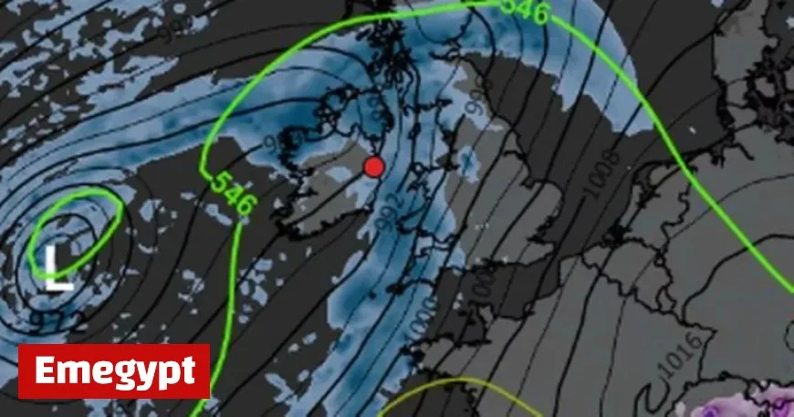
Forecast Overview
According to Cathal Nolan from Ireland’s Weather Channel, temperatures could plummet to between -2°C and -4°C. Nighttime conditions are expected to be particularly harsh, with nighttime frosts becoming common. Daytime highs will struggle to reach just 5°C to 7°C in many regions.
Key Weather Events Expected
- First Arctic blast anticipated next week.
- Temperatures dropping to -4°C in some areas.
- Severe night frosts likely.
- Heavy rain leading to flooding concerns before cold conditions arrive.
- Potential snowfall starting as early as November 19th or 20th.
Rainfall and Flooding Risks
Before this winter weather hits, Ireland will experience heavy rain, particularly affecting southern and eastern regions. Up to 140mm of rain could fall, heightening the risk of flooding.
Long-Range Weather Predictions
Met Éireann’s long-range forecasts suggest a northerly airflow may establish over Ireland, which could lead to a more settled weather pattern. Rainfall is expected to be near or below normal levels, with temperatures trending slightly below the seasonal average.
Daily Weather Highlights
| Day | Weather | Temperature Range (°C) |
|---|---|---|
| Tuesday | Clear spells and isolated showers; some mist. | 5 to 8 |
| Wednesday | Morning sunny spells; showery rain in the afternoon. | 10 to 12 |
| Thursday | Cloudy in the north; drier and brighter in the south. | 7 to 13 |
As the week unfolds, residents across Ireland should stay updated on weather advisories and prepare for the coming Arctic conditions. For ongoing updates, refer to reliable weather sources like Emegypt.


