


Major Snow Squalls Set to Hit London Barrie and Northern GTA This Sunday Expect 25 to 50cm of Snow
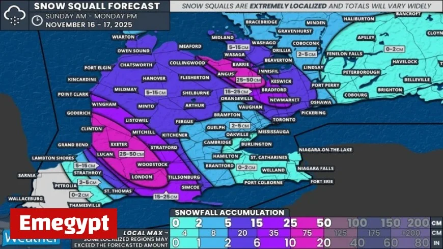
A major snow squall is expected to hit London, Barrie, and the Northern Greater Toronto Area (GTA) this Sunday. Snowfall totals are projected to be between 25 to 50 cm in specific regions, as intense and narrow snow bands are predicted.
Forecast Overview
This weather event illustrates the uncertainty inherent in snow squall predictions. The narrowness of the snow bands means snowfall can vary significantly over short distances. Therefore, the provided ranges are estimates and not guarantees.
Areas Most Affected
The Lake Huron region is forecasted to experience some of the heaviest snowfall. Key locations expected to see significant accumulation include:
- Goderich
- Clinton
- Lucan
- Exeter
- Mitchell
- London
In these areas, snowfall could exceed 25 to 50 cm. There is even a chance of localized spots receiving more than 50 cm.
Surrounding Regions
Adjacent areas, such as Grand Bend, Tillsonburg, Stratford, Wingham, and Point Clark, may see accumulations between 15 to 25 cm. As the weather system moves eastward, regions in Grey Bruce and Dufferin County can expect 5 to 15 cm mostly on Monday.
Regions Near Georgian Bay
The Georgian Bay area may experience a narrower band of snowfall. The corridor stretching from Collingwood through Angus to Innisfil is likely to receive 25 to 35 cm. If conditions intensify, areas could even reach 50 cm. The City of Barrie will be right on the edge of this system, with snow totals projected as follows:
- South end: 15 to 30 cm
- North end: 10 to 20 cm
Northern Greater Toronto Area Impacts
Significant snowfall will extend into the Northern GTA, including Bradford, Newmarket, and Aurora. Totals along the Highway 400 and 404 corridor are anticipated to be between 15 to 30 cm.
Other Areas in Southern Ontario
In the eastern parts of Toronto and Durham Region, areas like Ajax, Pickering, and Oshawa may experience occasional heavy bursts, resulting in an additional 5 to 10 cm of snow. The remainder of Southern Ontario is expected to see less than 5 cm of snow by Monday due to the lake effect.
Residents are advised to prepare for adverse weather conditions and potential travel disruptions as this snow squall approaches.


