


Cold Snap: Central Florida Feels-Like Temperatures Near Freezing
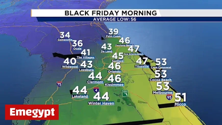
Central Florida is experiencing a significant drop in temperatures as a cold front sweeps through the region. The abrupt shift in weather is causing feel-like temperatures to approach freezing, especially on Thanksgiving night and into Friday morning.
Weather Analysis: Cold Snap in Central Florida
On Thursday, weather patterns turned active with heavy rain and strong winds moving from northwest to southeast, affecting counties including Marion, Lake, Sumter, Polk, and Osceola. As dry air from the north follows this system, temperatures are expected to plummet.
Temperature Forecast
- Thanksgiving night: Feels like temperatures could drop to near freezing.
- Friday morning: Areas north, particularly around Gainesville in Alachua County, will see temperatures close to freezing.
- General forecast for Friday:
- Actual temperatures near 32°F from Ocala to Palm Coast.
- Wind chill values expected between 33°F and 35°F.
To stay comfortable, residents are advised to layer up before heading outdoors. Wind conditions will intensify as high pressure moves into the area, further contributing to the chilling effect.
Weekend Outlook
As the weekend approaches, temperatures will begin to rebound. Saturday is projected to see highs reaching the mid-70s, while Sunday may bring low 80s, signaling a rapid transition away from the current chill. This period of colder weather, described as a “flash freeze,” is expected to be brief.
Looking Ahead
As December approaches, meteorological forecasts indicate the possibility of a developing low-pressure system beginning near Texas. This system may bring increased rain chances to northern Florida during the first days of the month. Keep an eye on weather updates as conditions could shift dramatically in the coming days.
For now, residents in Central Florida should prepare for this cold snap, ensuring they have their warm clothing ready while enjoying the holiday festivities. Safe travels and stay warm!


