


Indiana Braces for Heavy Snowfall with Winter Storm Alerts
Indiana is preparing for significant snowfall as winter storm watches have been issued across the region. This marks the first winter storm alert of the season for central Indiana, valid from late Friday night through Sunday afternoon.
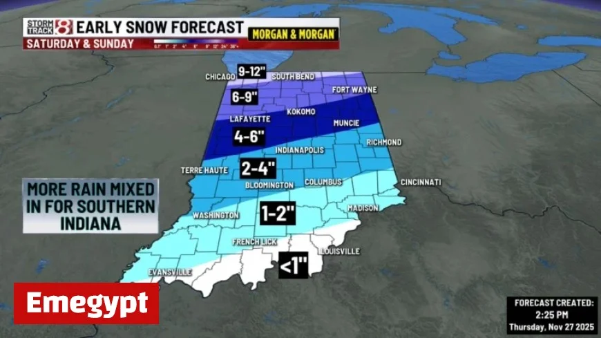
Winter Weather Impact Across Indiana
The National Weather Service has projected varying snow accumulations across different parts of Indiana. In central Indiana, including Indianapolis, snowfall is expected to begin Saturday afternoon. Meteorologists predict a transition from snow to rain as temperatures rise above freezing Saturday night.
Snow Accumulation Estimates
- Central Indiana: 3 to 7 inches, particularly affecting counties such as Boone, Delaware, and Marion.
- Northern Indiana: 5 to 12 inches, with higher amounts in counties like Adams and Allen.
- Northwest Indiana: More than 6 inches possible in Benton, Jasper, and Porter counties.
Travel conditions may become hazardous. The weather service has cautioned that snow may stick around due to cold temperatures following the storm, which are expected to remain in the teens and 20s early next week.
Snow Removal Efforts in Indianapolis
This snowfall will test the new snow removal strategy of the Indianapolis city government. Under the latest plan, residential streets will be cleared once snowfall reaches 4 inches. Streets near schools and township buildings will receive priority when accumulations hit 2 inches.
This change comes after residents voiced concerns about unplowed roads following a significant snowfall last January.
With further snow possible in Indianapolis on Monday, residents are advised to prepare for challenging travel conditions and possible delays. Stay updated with the latest forecasts and local advisories as this winter storm unfolds.


