


West Virginia Braces for Intense Winter Weather in Next 24 Hours
West Virginia is preparing for an intense winter storm expected to impact the state within the next 24 hours. This weather system, which has already affected the Midwest, is projected to arrive late Monday night. It will move from the southwestern counties northeastward, bringing various forms of precipitation.
Weather Forecast: A Mixed Bag of Precipitation
According to Jeremy Michael, a meteorologist with the National Weather Service in Charleston, residents can anticipate a mixture of rain, snow, sleet, and freezing rain. “A lot of these places will experience a wintry mix of weather,” he stated.
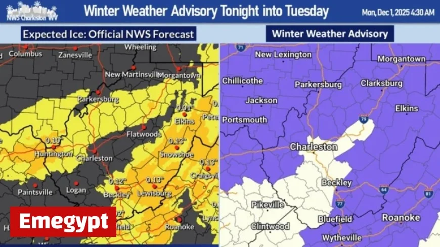
Winter Weather Advisory Details
The National Weather Service has issued a Winter Weather Advisory for nearly all counties in West Virginia. This advisory will be in effect from 11 p.m. on Monday until 1 p.m. on Tuesday. Travelers should be cautious, especially during the Tuesday morning rush hour.
- Timeframe: 11 p.m. Monday to 1 p.m. Tuesday
- Areas Affected: Southern and eastern counties are likely to face the worst conditions.
Impact on Travel
The I-79 corridor, particularly from Charleston to Braxton County, might experience predominantly rainy conditions. However, meteorologist Michael warns that even slight temperature fluctuations could lead to icy patches. “Don’t be surprised if that area turns icy,” he cautioned.
Precipitation Accumulations
Snow accumulations are forecasted to reach up to two inches, primarily in the western lowlands and mountainous areas. Additionally, all surfaces may experience ice accumulation.
Extended Weather Outlook
The storm system is expected to linger in the mountains and parts of the Eastern Panhandle late Tuesday. However, by Wednesday, dry conditions should return to most regions. The National Weather Service is also monitoring another weather system, which may impact the area later in the week.


