


Maine Braces for Season’s First Major Snowstorm: Key Details to Know
Maine is preparing for its first major snowstorm of the season, with significant snowfall expected across the region. The winter storm is projected to begin on Tuesday morning and continue through the night.
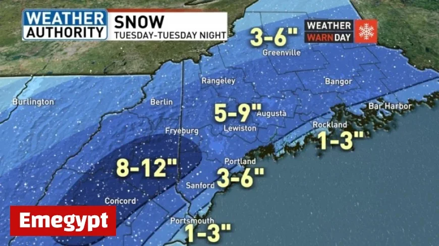
Snowstorm Timing and Accumulation
Snow is anticipated to start between 7:00 AM and 9:00 AM on Tuesday. It will taper off from 1:00 AM to 3:00 AM on Wednesday. The snowfall will vary in intensity depending on the area:
- Inland Areas: 5-9 inches
- Coastal Regions: 3-6 inches with rain expected to mix with snow
- Central New Hampshire to Western Maine: 8-12 inches in localized higher amounts
Wind and Weather Warnings
Light winds from the east to northeast will accompany the snowfall on Tuesday, shifting to northeast and north winds at 15 to 20 MPH later in the evening. The National Weather Service has issued Winter Storm Warnings and Winter Weather Advisories effective from 8 AM on Tuesday until 4 AM on Wednesday.
Coastal Impact
Rain is likely to limit snowfall accumulation along the coast. However, as temperatures drop in the evening, a transition to snow is expected, leading to increased snow totals overnight. Most regions will still receive notable accumulation despite coastal rain.
Post-Storm Forecast
Following the storm, conditions will improve. Skies are forecasted to clear on Wednesday morning, resulting in a pleasant mid-week day. However, an Arctic cold front is set to move through late Thursday, bringing another potential snow shower or squall.
With this front, a significant drop in temperatures is anticipated. Highs on Friday may struggle to reach the teens, while another light snow chance is possible on Saturday.
Residents in Maine are advised to stay updated and prepare for the first significant snow event of the season.


