


Jacksonville Braces for Dense Fog and Stormy Weather This Week
Jacksonville, Florida, is preparing for a week marked by dense fog and stormy weather. Residents are advised to take extra precautions while traveling due to significantly reduced visibility.
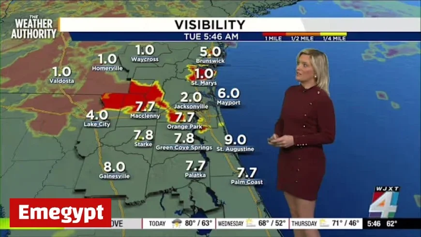
Dense Fog Conditions
This morning, visibility in Jacksonville has fallen to around two miles, with even lower visibility reported in nearby areas. Areas such as the airport and Southbank are particularly affected. Drivers should allow additional travel time, ensure their headlights are set to low beam, and remain vigilant for schoolchildren on their morning commute.
Travel Tips
- Keep headlights on low beam.
- Allow extra time for travel.
- Be cautious of pedestrians, especially children.
Incoming Rain and Storms
Jacksonville is experiencing its first significant rainfall in over a month. Following a remarkably dry November, during which the region recorded no precipitation, storm systems are moving in from the Gulf.
Residents can expect a 60% chance of rain or thunderstorms throughout the day. Although most storms are predicted to remain under severe levels, gusty winds may occur in certain areas. Radar data shows scattered showers throughout the region, indicating the potential for localized heavy rain.
Upcoming Weather Forecast
- Additional rain anticipated by Friday.
- Cooler temperatures with daytime highs dropping to the 60s.
- Overnight lows could reach the 40s by midweek.
Despite the cooler weather, a return to near-average temperatures is expected by the weekend. The humidity will also persist until Friday, contributing to the overall muggy conditions.
Outdoor Activities and Safety
For those considering outdoor plans, note that there is a moderate risk of rip currents along the beaches. Even if the sun briefly emerges, swimming may not be advisable.
Residents are encouraged to share their weather observations and photos with the community using the Snap JAX platform. Stay safe and monitor the weather conditions closely in the Jacksonville area.


